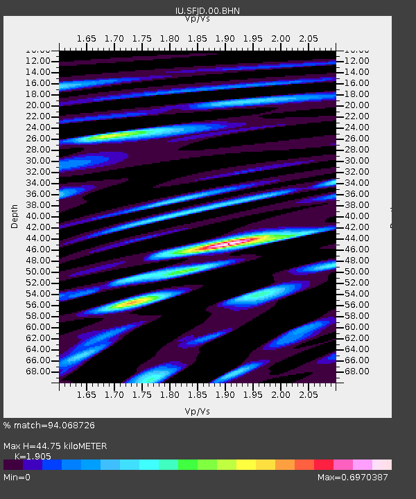
SFJD Sondre Stromfjord, Greenland - Earthquake Result Viewer
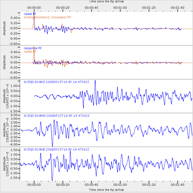
Earthquake location: Central Mid-Atlantic Ridge
Earthquake latitude/longitude: 7.3/-34.9
Earthquake time(UTC): 2008/05/23 (144) 19:35:34 GMT
Earthquake Depth: 9.0 km
Earthquake Magnitude: 6.0 MB, 6.4 MS, 6.5 MW, 6.5 MW
Earthquake Catalog/Contributor: WHDF/NEIC
Network: IU Global Seismograph Network (GSN - IRIS/USGS)
Station: SFJD Sondre Stromfjord, Greenland
Lat/Lon: 67.00 N/50.62 W
Elevation: 328 m
Distance: 60.6 deg
Az: 352.975 deg
Baz: 162.019 deg
Ray Param: 0.061455887
Estimated Moho Depth: 44.75 km
Estimated Crust Vp/Vs: 1.90
Assumed Crust Vp: 6.459 km/s
Estimated Crust Vs: 3.391 km/s
Estimated Crust Poisson's Ratio: 0.31
Radial Match: 94.068726 %
Radial Bump: 400
Transverse Match: 75.23033 %
Transverse Bump: 400
SOD ConfigId: 2504
Insert Time: 2010-03-03 15:08:36.300 +0000
GWidth: 2.5
Max Bumps: 400
Tol: 0.001

Signal To Noise

ChannelStoNSTALTA
IU:SFJD:00:BHN:20080523T19:45:14.47302Z5.11315978.8490054E-71.7306336E-7
IU:SFJD:00:BHE:20080523T19:45:14.47302Z6.89253334.2189865E-76.121097E-8
IU:SFJD:00:BHZ:20080523T19:45:14.47302Z3.62550853.8858974E-71.0718213E-7
Arrivals
Ps6.5 SECOND
PpPs19 SECOND
PsPs/PpSs26 SECOND