You are here: Home > Network List > CI - Caltech Regional Seismic Network Stations List
> Station SBC Santa Barbara, Santa Barbara, CA, USA > Earthquake Result Viewer
SBC Santa Barbara, Santa Barbara, CA, USA - Earthquake Result Viewer

| Earthquake location: |
Northwest Of Kuril Islands |
| Earthquake latitude/longitude: |
47.8/146.2 |
| Earthquake time(UTC): |
2002/11/17 (321) 04:53:53 GMT |
| Earthquake Depth: |
459 km |
| Earthquake Magnitude: |
7.3 MW, 7.3 MW |
| Earthquake Catalog/Contributor: |
WHDF/NEIC |
|
| Network: |
CI Caltech Regional Seismic Network |
| Station: |
SBC Santa Barbara, Santa Barbara, CA, USA |
| Lat/Lon: |
34.44 N/119.71 W |
| Elevation: |
94 m |
|
| Distance: |
67.9 deg |
| Az: |
62.849 deg |
| Baz: |
313.488 deg |
| Ray Param: |
0.055130016 |
| Estimated Moho Depth: |
29.5 km |
| Estimated Crust Vp/Vs: |
1.85 |
| Assumed Crust Vp: |
6.1 km/s |
| Estimated Crust Vs: |
3.297 km/s |
| Estimated Crust Poisson's Ratio: |
0.29 |
|
| Radial Match: |
83.24766 % |
| Radial Bump: |
400 |
| Transverse Match: |
77.1765 % |
| Transverse Bump: |
400 |
| SOD ConfigId: |
3787 |
| Insert Time: |
2010-02-25 21:34:22.768 +0000 |
| GWidth: |
2.5 |
| Max Bumps: |
400 |
| Tol: |
0.001 |
|
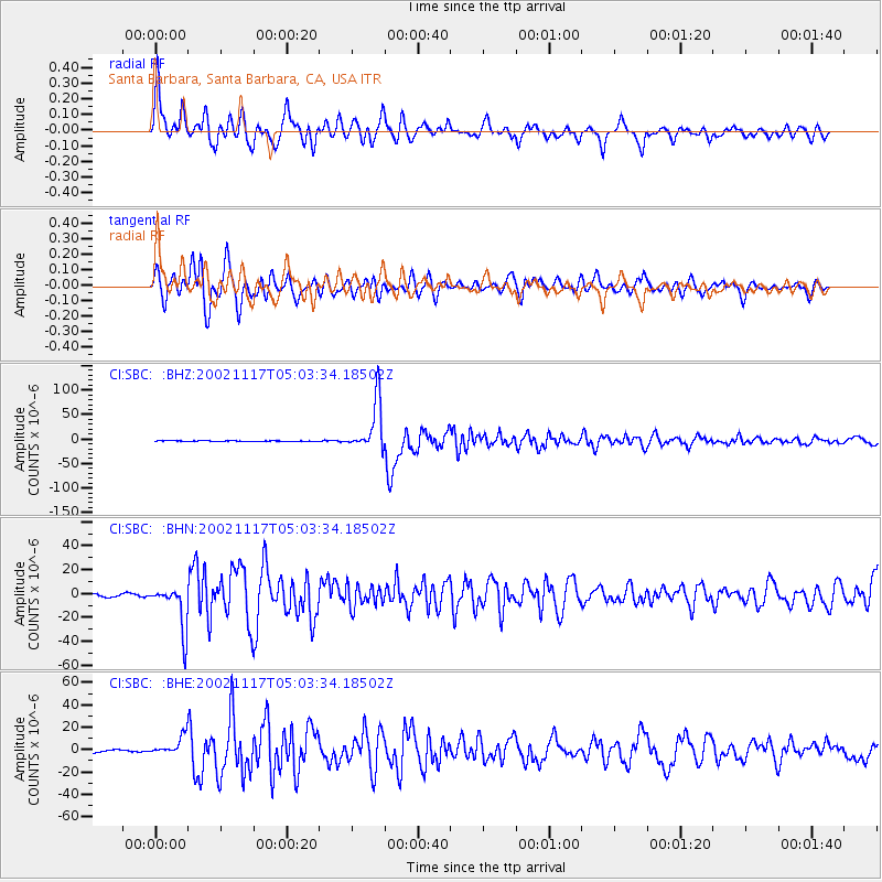
Signal To Noise
| Channel | StoN | STA | LTA |
| CI:SBC: :BHN:20021117T05:03:34.18502Z | 17.620485 | 1.8704366E-5 | 1.0615125E-6 |
| CI:SBC: :BHE:20021117T05:03:34.18502Z | 4.622868 | 8.2041815E-6 | 1.7746951E-6 |
| CI:SBC: :BHZ:20021117T05:03:34.18502Z | 120.174065 | 5.074007E-5 | 4.2222146E-7 |
| Arrivals |
| Ps | 4.2 SECOND |
| PpPs | 13 SECOND |
| PsPs/PpSs | 18 SECOND |


