You are here: Home > Network List > TA - USArray Transportable Network (new EarthScope stations) Stations List
> Station A21K Barrow, AK, USA > Earthquake Result Viewer
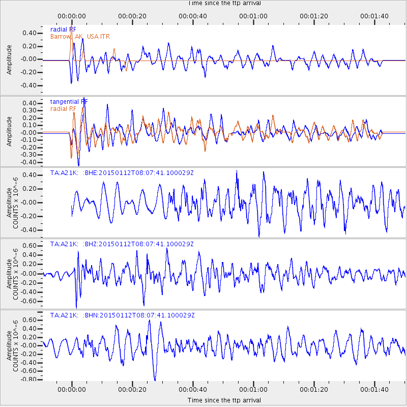
A21K Barrow, AK, USA - Earthquake Result Viewer
*The percent match for this event was below the threshold and hence no stack was calculated.
| Earthquake location: |
Near Coast Of Chiapas, Mexico |
| Earthquake latitude/longitude: |
15.5/-93.4 |
| Earthquake time(UTC): |
2015/01/12 (012) 07:57:27 GMT |
| Earthquake Depth: |
75 km |
| Earthquake Magnitude: |
5.5 MWW, 5.5 MWC, 5.5 MWB |
| Earthquake Catalog/Contributor: |
NEIC PDE/NEIC COMCAT |
|
| Network: |
TA USArray Transportable Network (new EarthScope stations) |
| Station: |
A21K Barrow, AK, USA |
| Lat/Lon: |
71.32 N/156.62 W |
| Elevation: |
577 m |
|
| Distance: |
67.0 deg |
| Az: |
341.788 deg |
| Baz: |
110.717 deg |
| Ray Param: |
$rayparam |
*The percent match for this event was below the threshold and hence was not used in the summary stack. |
|
| Radial Match: |
60.06057 % |
| Radial Bump: |
400 |
| Transverse Match: |
53.787872 % |
| Transverse Bump: |
385 |
| SOD ConfigId: |
872571 |
| Insert Time: |
2015-02-19 09:14:52.416 +0000 |
| GWidth: |
2.5 |
| Max Bumps: |
400 |
| Tol: |
0.001 |
|
Signal To Noise
| Channel | StoN | STA | LTA |
| TA:A21K: :BHZ:20150112T08:07:41.100029Z | 2.1248877 | 2.581832E-7 | 1.215044E-7 |
| TA:A21K: :BHN:20150112T08:07:41.100029Z | 0.5829082 | 1.3433647E-7 | 2.3045905E-7 |
| TA:A21K: :BHE:20150112T08:07:41.100029Z | 1.1116524 | 1.4858564E-7 | 1.3366196E-7 |
| Arrivals |
| Ps | |
| PpPs | |
| PsPs/PpSs | |


