You are here: Home > Network List > IU - Global Seismograph Network (GSN - IRIS/USGS) Stations List
> Station SFJD Sondre Stromfjord, Greenland > Earthquake Result Viewer
SFJD Sondre Stromfjord, Greenland - Earthquake Result Viewer
| Earthquake location: |
Sea Of Japan |
| Earthquake latitude/longitude: |
36.8/134.9 |
| Earthquake time(UTC): |
2007/07/16 (197) 14:17:37 GMT |
| Earthquake Depth: |
350 km |
| Earthquake Magnitude: |
6.2 MB, 6.8 MW, 6.8 MW |
| Earthquake Catalog/Contributor: |
WHDF/NEIC |
|
| Network: |
IU Global Seismograph Network (GSN - IRIS/USGS) |
| Station: |
SFJD Sondre Stromfjord, Greenland |
| Lat/Lon: |
67.00 N/50.62 W |
| Elevation: |
328 m |
|
| Distance: |
76.4 deg |
| Az: |
2.209 deg |
| Baz: |
355.485 deg |
| Ray Param: |
0.05000826 |
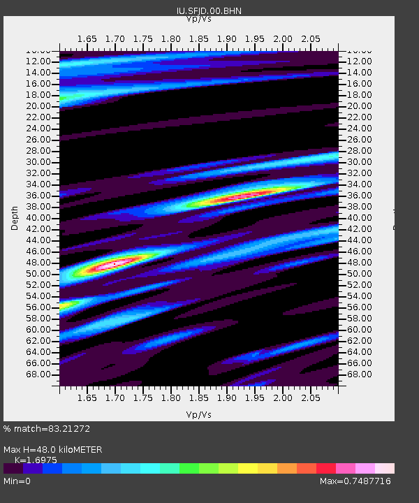
| Estimated Moho Depth: |
48.0 km |
| Estimated Crust Vp/Vs: |
1.70 |
| Assumed Crust Vp: |
6.459 km/s |
| Estimated Crust Vs: |
3.805 km/s |
| Estimated Crust Poisson's Ratio: |
0.23 |
|
| Radial Match: |
83.21272 % |
| Radial Bump: |
377 |
| Transverse Match: |
74.00153 % |
| Transverse Bump: |
400 |
| SOD ConfigId: |
2564 |
| Insert Time: |
2010-03-03 15:09:00.390 +0000 |
| GWidth: |
2.5 |
| Max Bumps: |
400 |
| Tol: |
0.001 |
|
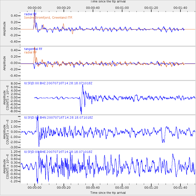
Signal To Noise
| Channel | StoN | STA | LTA |
| IU:SFJD:00:BHN:20070716T14:28:18.071018Z | 8.098162 | 1.3910458E-6 | 1.7177304E-7 |
| IU:SFJD:00:BHE:20070716T14:28:18.071018Z | 2.796814 | 5.7354913E-7 | 2.0507233E-7 |
| IU:SFJD:00:BHZ:20070716T14:28:18.071018Z | 14.006726 | 3.9685233E-6 | 2.8332983E-7 |
| Arrivals |
| Ps | 5.4 SECOND |
| PpPs | 19 SECOND |
| PsPs/PpSs | 25 SECOND |


