You are here: Home > Network List > TA - USArray Transportable Network (new EarthScope stations) Stations List
> Station J04D Umpqua National Forest, Toketee, OR, USA > Earthquake Result Viewer
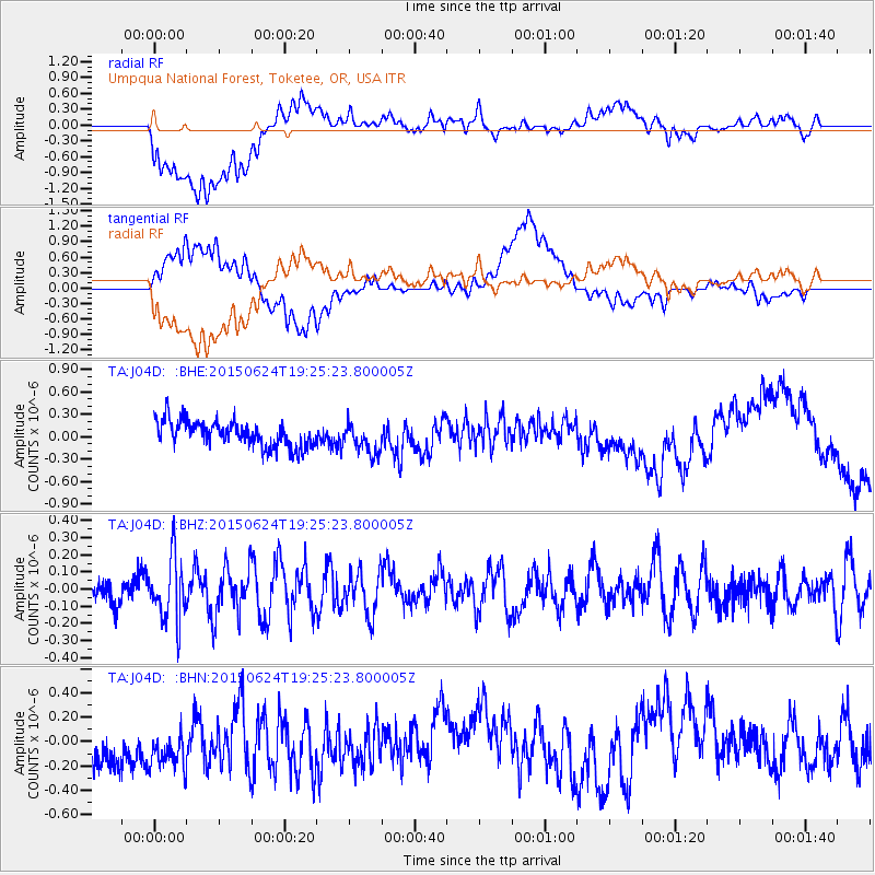
J04D Umpqua National Forest, Toketee, OR, USA - Earthquake Result Viewer
*The percent match for this event was below the threshold and hence no stack was calculated.
| Earthquake location: |
Southern Xinjiang, China |
| Earthquake latitude/longitude: |
41.8/88.4 |
| Earthquake time(UTC): |
2015/06/24 (175) 19:12:53 GMT |
| Earthquake Depth: |
29 km |
| Earthquake Magnitude: |
5.1 MW, 5.3 mb, 4.6 MS |
| Earthquake Catalog/Contributor: |
ISC/ISC |
|
| Network: |
TA USArray Transportable Network (new EarthScope stations) |
| Station: |
J04D Umpqua National Forest, Toketee, OR, USA |
| Lat/Lon: |
43.24 N/122.11 W |
| Elevation: |
1948 m |
|
| Distance: |
91.0 deg |
| Az: |
21.752 deg |
| Baz: |
337.726 deg |
| Ray Param: |
$rayparam |
*The percent match for this event was below the threshold and hence was not used in the summary stack. |
|
| Radial Match: |
57.68494 % |
| Radial Bump: |
400 |
| Transverse Match: |
49.776474 % |
| Transverse Bump: |
400 |
| SOD ConfigId: |
7422571 |
| Insert Time: |
2019-04-19 11:09:33.423 +0000 |
| GWidth: |
2.5 |
| Max Bumps: |
400 |
| Tol: |
0.001 |
|
Signal To Noise
| Channel | StoN | STA | LTA |
| TA:J04D: :BHZ:20150624T19:25:23.800005Z | 2.409299 | 1.7970471E-7 | 7.458797E-8 |
| TA:J04D: :BHN:20150624T19:25:23.800005Z | 1.2595948 | 2.915614E-7 | 2.3147238E-7 |
| TA:J04D: :BHE:20150624T19:25:23.800005Z | 1.2034492 | 2.0549412E-7 | 1.7075428E-7 |
| Arrivals |
| Ps | |
| PpPs | |
| PsPs/PpSs | |


