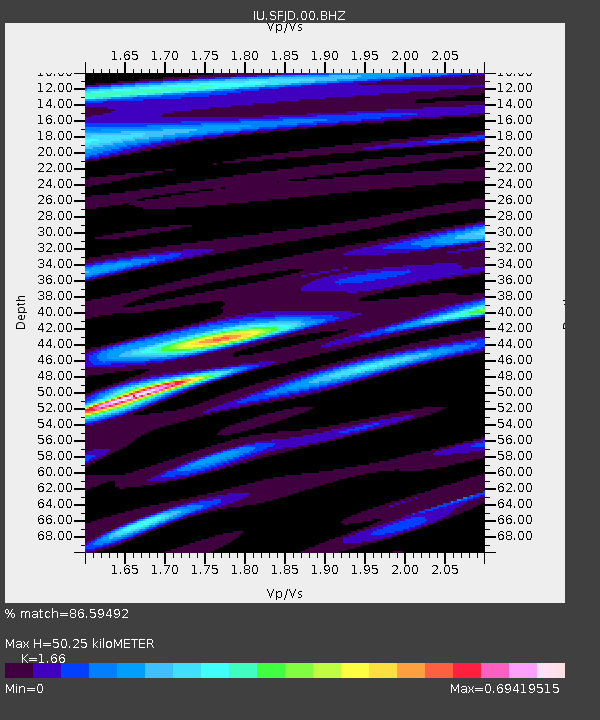
SFJD Sondre Stromfjord, Greenland - Earthquake Result Viewer
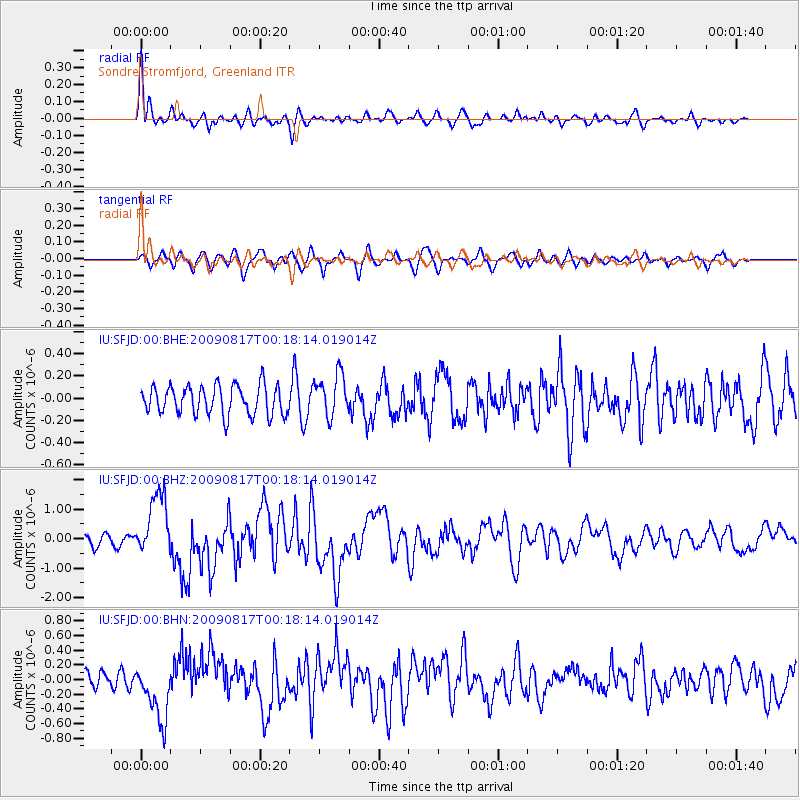
Earthquake location: Southwestern Ryukyu Isl., Japan
Earthquake latitude/longitude: 23.5/123.5
Earthquake time(UTC): 2009/08/17 (229) 00:05:49 GMT
Earthquake Depth: 20 km
Earthquake Magnitude: 6.2 MB, 6.6 MS, 6.7 MW, 6.6 MW
Earthquake Catalog/Contributor: WHDF/NEIC
Network: IU Global Seismograph Network (GSN - IRIS/USGS)
Station: SFJD Sondre Stromfjord, Greenland
Lat/Lon: 67.00 N/50.62 W
Elevation: 330 m
Distance: 89.7 deg
Az: 357.692 deg
Baz: 5.397 deg
Ray Param: 0.041726306
Estimated Moho Depth: 50.25 km
Estimated Crust Vp/Vs: 1.66
Assumed Crust Vp: 6.459 km/s
Estimated Crust Vs: 3.891 km/s
Estimated Crust Poisson's Ratio: 0.22
Radial Match: 86.59492 %
Radial Bump: 400
Transverse Match: 64.47126 %
Transverse Bump: 400
SOD ConfigId: 2622
Insert Time: 2010-03-03 15:09:07.572 +0000
GWidth: 2.5
Max Bumps: 400
Tol: 0.001

Signal To Noise

ChannelStoNSTALTA
IU:SFJD:00:BHZ:20090817T00:18:14.019014Z7.7966421.0936357E-61.4027009E-7
IU:SFJD:00:BHN:20090817T00:18:14.019014Z4.8132933.995229E-78.300407E-8
IU:SFJD:00:BHE:20090817T00:18:14.019014Z1.45562271.8989404E-71.3045555E-7
Arrivals
Ps5.3 SECOND
PpPs20 SECOND
PsPs/PpSs25 SECOND