You are here: Home > Network List > IU - Global Seismograph Network (GSN - IRIS/USGS) Stations List
> Station SFJD Sondre Stromfjord, Greenland > Earthquake Result Viewer
SFJD Sondre Stromfjord, Greenland - Earthquake Result Viewer
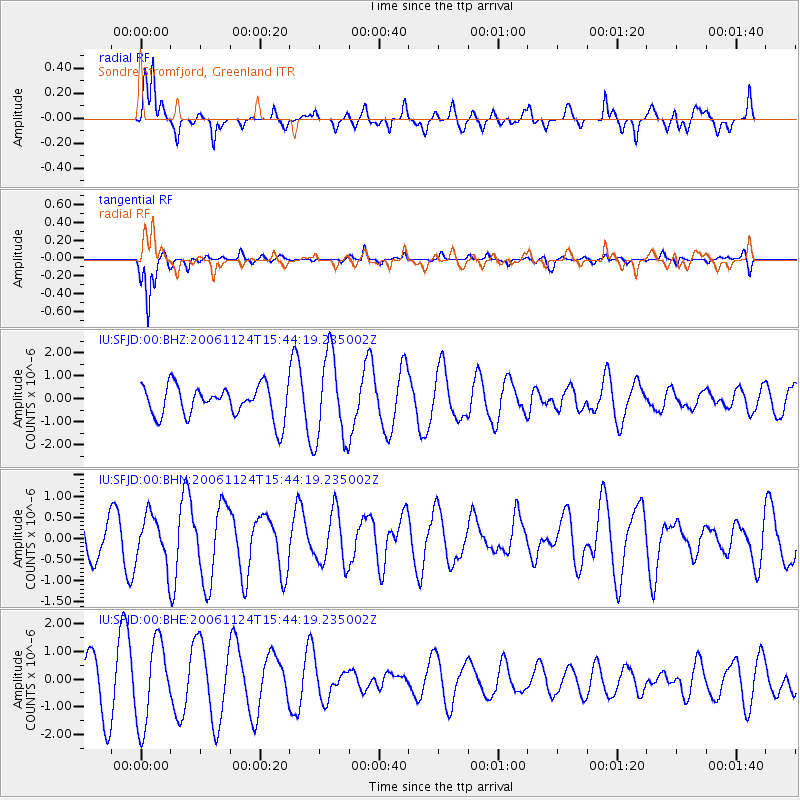
| Earthquake location: |
Kuril Islands |
| Earthquake latitude/longitude: |
46.8/153.8 |
| Earthquake time(UTC): |
2006/11/24 (328) 15:34:10 GMT |
| Earthquake Depth: |
11 km |
| Earthquake Magnitude: |
5.7 MB, 4.9 MS, 5.5 MW, 5.3 MW |
| Earthquake Catalog/Contributor: |
WHDF/NEIC |
|
| Network: |
IU Global Seismograph Network (GSN - IRIS/USGS) |
| Station: |
SFJD Sondre Stromfjord, Greenland |
| Lat/Lon: |
67.00 N/50.62 W |
| Elevation: |
328 m |
|
| Distance: |
65.1 deg |
| Az: |
10.313 deg |
| Baz: |
341.751 deg |
| Ray Param: |
0.058518905 |
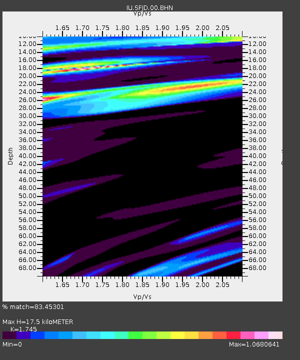
| Estimated Moho Depth: |
17.5 km |
| Estimated Crust Vp/Vs: |
1.75 |
| Assumed Crust Vp: |
6.459 km/s |
| Estimated Crust Vs: |
3.702 km/s |
| Estimated Crust Poisson's Ratio: |
0.26 |
|
| Radial Match: |
83.45301 % |
| Radial Bump: |
400 |
| Transverse Match: |
89.52379 % |
| Transverse Bump: |
257 |
| SOD ConfigId: |
2564 |
| Insert Time: |
2010-03-03 15:09:14.263 +0000 |
| GWidth: |
2.5 |
| Max Bumps: |
400 |
| Tol: |
0.001 |
|
Signal To Noise
| Channel | StoN | STA | LTA |
| IU:SFJD:00:BHN:20061124T15:44:19.235002Z | 1.2007538 | 5.6389763E-7 | 4.696197E-7 |
| IU:SFJD:00:BHE:20061124T15:44:19.235002Z | 2.1854968 | 1.5176723E-6 | 6.94429E-7 |
| IU:SFJD:00:BHZ:20061124T15:44:19.235002Z | 2.6819525 | 1.859297E-6 | 6.9326245E-7 |
| Arrivals |
| Ps | 2.1 SECOND |
| PpPs | 7.1 SECOND |
| PsPs/PpSs | 9.2 SECOND |


