You are here: Home > Network List > CI - Caltech Regional Seismic Network Stations List
> Station SBC Santa Barbara, Santa Barbara, CA, USA > Earthquake Result Viewer
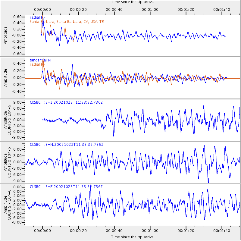
SBC Santa Barbara, Santa Barbara, CA, USA - Earthquake Result Viewer

| Earthquake location: |
Central Alaska |
| Earthquake latitude/longitude: |
63.5/-147.9 |
| Earthquake time(UTC): |
2002/10/23 (296) 11:27:19 GMT |
| Earthquake Depth: |
4.2 km |
| Earthquake Magnitude: |
6.0 MB, 6.7 MS, 6.7 MW, 6.7 MW |
| Earthquake Catalog/Contributor: |
WHDF/NEIC |
|
| Network: |
CI Caltech Regional Seismic Network |
| Station: |
SBC Santa Barbara, Santa Barbara, CA, USA |
| Lat/Lon: |
34.44 N/119.71 W |
| Elevation: |
94 m |
|
| Distance: |
33.9 deg |
| Az: |
135.59 deg |
| Baz: |
337.688 deg |
| Ray Param: |
0.07799732 |
| Estimated Moho Depth: |
41.25 km |
| Estimated Crust Vp/Vs: |
1.88 |
| Assumed Crust Vp: |
6.1 km/s |
| Estimated Crust Vs: |
3.236 km/s |
| Estimated Crust Poisson's Ratio: |
0.30 |
|
| Radial Match: |
80.3324 % |
| Radial Bump: |
400 |
| Transverse Match: |
74.91739 % |
| Transverse Bump: |
400 |
| SOD ConfigId: |
3787 |
| Insert Time: |
2010-02-25 21:34:27.184 +0000 |
| GWidth: |
2.5 |
| Max Bumps: |
400 |
| Tol: |
0.001 |
|
Signal To Noise
| Channel | StoN | STA | LTA |
| CI:SBC: :BHN:20021023T11:33:32.736Z | 1.5231633 | 1.0951186E-6 | 7.1897654E-7 |
| CI:SBC: :BHE:20021023T11:33:32.736Z | 1.0640302 | 9.0246965E-7 | 8.4816173E-7 |
| CI:SBC: :BHZ:20021023T11:33:32.736Z | 3.307983 | 2.1151984E-6 | 6.3942247E-7 |
| Arrivals |
| Ps | 6.4 SECOND |
| PpPs | 18 SECOND |
| PsPs/PpSs | 25 SECOND |


