You are here: Home > Network List > IU - Global Seismograph Network (GSN - IRIS/USGS) Stations List
> Station MIDW Midway Island, USA > Earthquake Result Viewer
MIDW Midway Island, USA - Earthquake Result Viewer

| Earthquake location: |
Solomon Islands |
| Earthquake latitude/longitude: |
-11.0/162.2 |
| Earthquake time(UTC): |
2004/10/08 (282) 08:27:53 GMT |
| Earthquake Depth: |
36 km |
| Earthquake Magnitude: |
6.1 MB, 6.9 MS, 6.8 MW, 6.8 MW |
| Earthquake Catalog/Contributor: |
WHDF/NEIC |
|
| Network: |
IU Global Seismograph Network (GSN - IRIS/USGS) |
| Station: |
MIDW Midway Island, USA |
| Lat/Lon: |
28.22 N/177.37 W |
| Elevation: |
18 m |
|
| Distance: |
43.7 deg |
| Az: |
26.539 deg |
| Baz: |
209.815 deg |
| Ray Param: |
0.07231258 |
| Estimated Moho Depth: |
28.0 km |
| Estimated Crust Vp/Vs: |
2.06 |
| Assumed Crust Vp: |
4.24 km/s |
| Estimated Crust Vs: |
2.058 km/s |
| Estimated Crust Poisson's Ratio: |
0.35 |
|
| Radial Match: |
85.90652 % |
| Radial Bump: |
400 |
| Transverse Match: |
78.89308 % |
| Transverse Bump: |
400 |
| SOD ConfigId: |
2459 |
| Insert Time: |
2010-03-03 15:10:20.909 +0000 |
| GWidth: |
2.5 |
| Max Bumps: |
400 |
| Tol: |
0.001 |
|
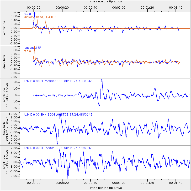
Signal To Noise
| Channel | StoN | STA | LTA |
| IU:MIDW:00:BHN:20041008T08:35:24.486014Z | 1.0314496 | 1.1395445E-6 | 1.104799E-6 |
| IU:MIDW:00:BHE:20041008T08:35:24.486014Z | 0.9583483 | 1.096265E-6 | 1.1439108E-6 |
| IU:MIDW:00:BHZ:20041008T08:35:24.486014Z | 4.089242 | 2.9589598E-6 | 7.235962E-7 |
| Arrivals |
| Ps | 7.2 SECOND |
| PpPs | 20 SECOND |
| PsPs/PpSs | 27 SECOND |


