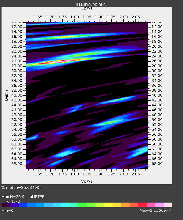
MIDW Midway Island, USA - Earthquake Result Viewer

Earthquake location: Near S. Coast Of Western Honshu
Earthquake latitude/longitude: 33.1/136.6
Earthquake time(UTC): 2004/09/05 (249) 10:07:07 GMT
Earthquake Depth: 14 km
Earthquake Magnitude: 6.7 MB, 7.0 MS, 7.2 MW, 7.0 MW
Earthquake Catalog/Contributor: WHDF/NEIC
Network: IU Global Seismograph Network (GSN - IRIS/USGS)
Station: MIDW Midway Island, USA
Lat/Lon: 28.22 N/177.37 W
Elevation: 18 m
Distance: 39.6 deg
Az: 84.417 deg
Baz: 288.743 deg
Ray Param: 0.07485722
Estimated Moho Depth: 26.0 km
Estimated Crust Vp/Vs: 1.73
Assumed Crust Vp: 4.24 km/s
Estimated Crust Vs: 2.451 km/s
Estimated Crust Poisson's Ratio: 0.25
Radial Match: 85.034904 %
Radial Bump: 400
Transverse Match: 65.39926 %
Transverse Bump: 400
SOD ConfigId: 2459
Insert Time: 2010-03-03 15:10:21.703 +0000
GWidth: 2.5
Max Bumps: 400
Tol: 0.001

Signal To Noise

ChannelStoNSTALTA
IU:MIDW:00:BHN:20040905T10:14:08.18499Z1.51430674.397508E-62.9039743E-6
IU:MIDW:00:BHE:20040905T10:14:08.18499Z3.85282429.440223E-62.4502085E-6
IU:MIDW:00:BHZ:20040905T10:14:08.18499Z8.3208221.2422158E-51.4929003E-6
Arrivals
Ps4.6 SECOND
PpPs16 SECOND
PsPs/PpSs21 SECOND