You are here: Home > Network List > IU - Global Seismograph Network (GSN - IRIS/USGS) Stations List
> Station MIDW Midway Island, USA > Earthquake Result Viewer
MIDW Midway Island, USA - Earthquake Result Viewer

| Earthquake location: |
Timor Region |
| Earthquake latitude/longitude: |
-8.2/124.9 |
| Earthquake time(UTC): |
2004/11/11 (316) 21:26:41 GMT |
| Earthquake Depth: |
10 km |
| Earthquake Magnitude: |
6.5 MB, 7.3 MS, 7.5 MW, 7.4 MW |
| Earthquake Catalog/Contributor: |
WHDF/NEIC |
|
| Network: |
IU Global Seismograph Network (GSN - IRIS/USGS) |
| Station: |
MIDW Midway Island, USA |
| Lat/Lon: |
28.22 N/177.37 W |
| Elevation: |
18 m |
|
| Distance: |
66.4 deg |
| Az: |
54.525 deg |
| Baz: |
246.008 deg |
| Ray Param: |
0.057618823 |
| Estimated Moho Depth: |
16.5 km |
| Estimated Crust Vp/Vs: |
1.80 |
| Assumed Crust Vp: |
4.24 km/s |
| Estimated Crust Vs: |
2.352 km/s |
| Estimated Crust Poisson's Ratio: |
0.28 |
|
| Radial Match: |
92.49289 % |
| Radial Bump: |
400 |
| Transverse Match: |
66.71985 % |
| Transverse Bump: |
400 |
| SOD ConfigId: |
2459 |
| Insert Time: |
2010-03-03 15:10:23.754 +0000 |
| GWidth: |
2.5 |
| Max Bumps: |
400 |
| Tol: |
0.001 |
|
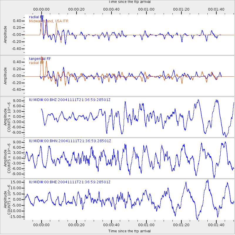
Signal To Noise
| Channel | StoN | STA | LTA |
| IU:MIDW:00:BHN:20041111T21:36:59.28501Z | 2.4528527 | 4.747656E-6 | 1.935565E-6 |
| IU:MIDW:00:BHE:20041111T21:36:59.28501Z | 1.2789145 | 2.9596304E-6 | 2.3141738E-6 |
| IU:MIDW:00:BHZ:20041111T21:36:59.28501Z | 1.3791877 | 2.3952098E-6 | 1.7366815E-6 |
| Arrivals |
| Ps | 3.2 SECOND |
| PpPs | 11 SECOND |
| PsPs/PpSs | 14 SECOND |


