You are here: Home > Network List > IU - Global Seismograph Network (GSN - IRIS/USGS) Stations List
> Station MIDW Midway Island, USA > Earthquake Result Viewer
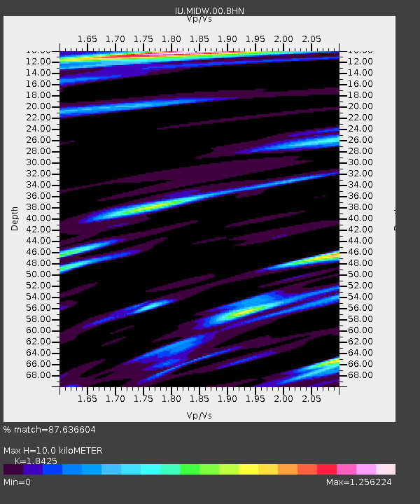
MIDW Midway Island, USA - Earthquake Result Viewer
| Earthquake location: |
Macquarie Island Region |
| Earthquake latitude/longitude: |
-55.7/158.5 |
| Earthquake time(UTC): |
2008/04/12 (103) 00:30:12 GMT |
| Earthquake Depth: |
16 km |
| Earthquake Magnitude: |
6.8 MB, 7.1 MS, 7.1 MW, 7.1 MW |
| Earthquake Catalog/Contributor: |
WHDF/NEIC |
|
| Network: |
IU Global Seismograph Network (GSN - IRIS/USGS) |
| Station: |
MIDW Midway Island, USA |
| Lat/Lon: |
28.22 N/177.37 W |
| Elevation: |
18 m |
|
| Distance: |
86.1 deg |
| Az: |
21.241 deg |
| Baz: |
193.451 deg |
| Ray Param: |
0.04430719 |
| Estimated Moho Depth: |
10.0 km |
| Estimated Crust Vp/Vs: |
1.84 |
| Assumed Crust Vp: |
4.24 km/s |
| Estimated Crust Vs: |
2.301 km/s |
| Estimated Crust Poisson's Ratio: |
0.29 |
|
| Radial Match: |
87.636604 % |
| Radial Bump: |
400 |
| Transverse Match: |
71.27655 % |
| Transverse Bump: |
400 |
| SOD ConfigId: |
2504 |
| Insert Time: |
2010-03-03 15:10:30.663 +0000 |
| GWidth: |
2.5 |
| Max Bumps: |
400 |
| Tol: |
0.001 |
|

Signal To Noise
| Channel | StoN | STA | LTA |
| IU:MIDW:00:BHN:20080412T00:42:20.896997Z | 7.0997605 | 7.5055714E-6 | 1.0571584E-6 |
| IU:MIDW:00:BHE:20080412T00:42:20.896997Z | 2.2369661 | 3.1072104E-6 | 1.3890289E-6 |
| IU:MIDW:00:BHZ:20080412T00:42:20.896997Z | 0.7644154 | 1.240198E-6 | 1.6224136E-6 |
| Arrivals |
| Ps | 2.0 SECOND |
| PpPs | 6.6 SECOND |
| PsPs/PpSs | 8.6 SECOND |


