You are here: Home > Network List > N4 - Central and EAstern US Network Stations List
> Station I45A Fountain, MI, USA > Earthquake Result Viewer
I45A Fountain, MI, USA - Earthquake Result Viewer
| Earthquake location: |
Southern Alaska |
| Earthquake latitude/longitude: |
61.7/-152.0 |
| Earthquake time(UTC): |
2015/06/24 (175) 22:32:20 GMT |
| Earthquake Depth: |
105 km |
| Earthquake Magnitude: |
5.7 MB, 6.2 MB |
| Earthquake Catalog/Contributor: |
NEIC PDE/NEIC ALERT |
|
| Network: |
N4 Central and EAstern US Network |
| Station: |
I45A Fountain, MI, USA |
| Lat/Lon: |
44.04 N/86.23 W |
| Elevation: |
215 m |
|
| Distance: |
41.4 deg |
| Az: |
83.98 deg |
| Baz: |
318.979 deg |
| Ray Param: |
0.07344186 |
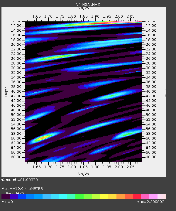
| Estimated Moho Depth: |
10.0 km |
| Estimated Crust Vp/Vs: |
2.04 |
| Assumed Crust Vp: |
6.53 km/s |
| Estimated Crust Vs: |
3.197 km/s |
| Estimated Crust Poisson's Ratio: |
0.34 |
|
| Radial Match: |
81.99379 % |
| Radial Bump: |
400 |
| Transverse Match: |
60.237545 % |
| Transverse Bump: |
400 |
| SOD ConfigId: |
7422571 |
| Insert Time: |
2019-04-19 11:21:19.397 +0000 |
| GWidth: |
2.5 |
| Max Bumps: |
400 |
| Tol: |
0.001 |
|

Signal To Noise
| Channel | StoN | STA | LTA |
| N4:I45A: :HHZ:20150624T22:39:24.690002Z | 4.125969 | 1.1828346E-6 | 2.8668043E-7 |
| N4:I45A: :HHN:20150624T22:39:24.690002Z | 4.5858026 | 1.3055397E-6 | 2.8469168E-7 |
| N4:I45A: :HHE:20150624T22:39:24.690002Z | 4.136285 | 1.2530375E-6 | 3.029379E-7 |
| Arrivals |
| Ps | 1.7 SECOND |
| PpPs | 4.4 SECOND |
| PsPs/PpSs | 6.1 SECOND |


