You are here: Home > Network List > IU - Global Seismograph Network (GSN - IRIS/USGS) Stations List
> Station MIDW Midway Island, USA > Earthquake Result Viewer
MIDW Midway Island, USA - Earthquake Result Viewer

| Earthquake location: |
South Of Fiji Islands |
| Earthquake latitude/longitude: |
-26.0/-177.5 |
| Earthquake time(UTC): |
2007/12/09 (343) 07:28:20 GMT |
| Earthquake Depth: |
152 km |
| Earthquake Magnitude: |
7.0 MB, 7.8 MW, 7.7 MW |
| Earthquake Catalog/Contributor: |
WHDF/NEIC |
|
| Network: |
IU Global Seismograph Network (GSN - IRIS/USGS) |
| Station: |
MIDW Midway Island, USA |
| Lat/Lon: |
28.22 N/177.37 W |
| Elevation: |
18 m |
|
| Distance: |
53.9 deg |
| Az: |
0.158 deg |
| Baz: |
180.161 deg |
| Ray Param: |
0.065297484 |
| Estimated Moho Depth: |
68.75 km |
| Estimated Crust Vp/Vs: |
1.93 |
| Assumed Crust Vp: |
4.24 km/s |
| Estimated Crust Vs: |
2.197 km/s |
| Estimated Crust Poisson's Ratio: |
0.32 |
|
| Radial Match: |
88.37949 % |
| Radial Bump: |
400 |
| Transverse Match: |
80.08236 % |
| Transverse Bump: |
400 |
| SOD ConfigId: |
2564 |
| Insert Time: |
2010-03-03 15:10:45.413 +0000 |
| GWidth: |
2.5 |
| Max Bumps: |
400 |
| Tol: |
0.001 |
|
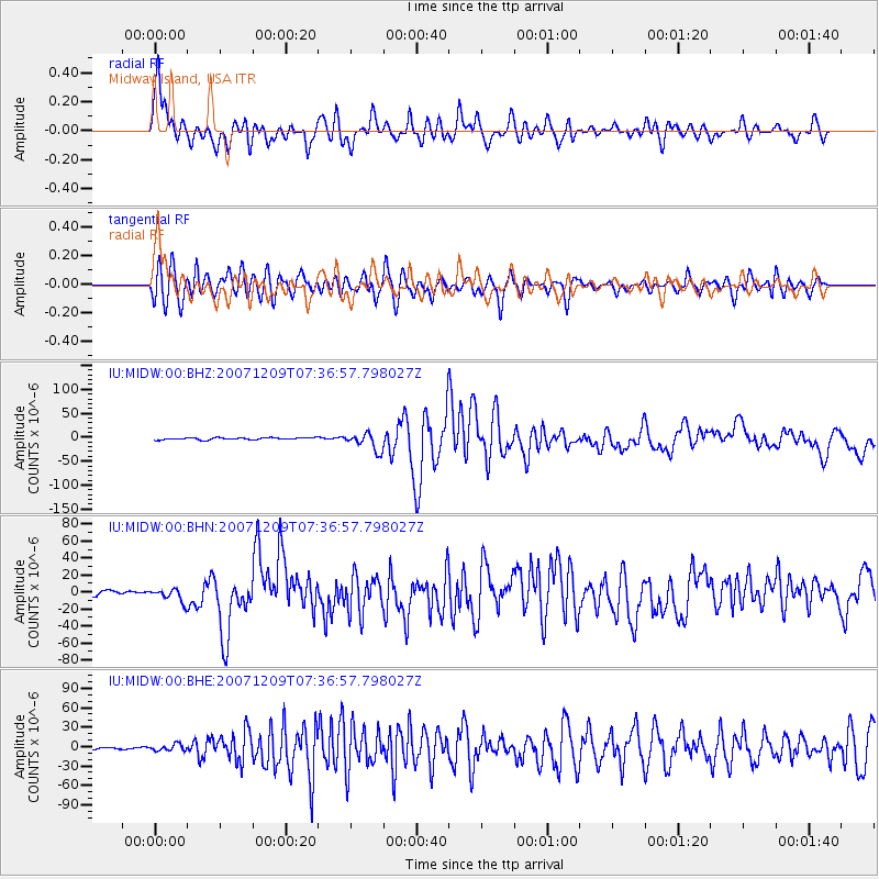
Signal To Noise
| Channel | StoN | STA | LTA |
| IU:MIDW:00:BHN:20071209T07:36:57.798027Z | 2.106321 | 7.885165E-6 | 3.7435725E-6 |
| IU:MIDW:00:BHE:20071209T07:36:57.798027Z | 2.1782293 | 4.8561337E-6 | 2.229395E-6 |
| IU:MIDW:00:BHZ:20071209T07:36:57.798027Z | 8.543818 | 1.846058E-5 | 2.1606943E-6 |
| Arrivals |
| Ps | 15 SECOND |
| PpPs | 47 SECOND |
| PsPs/PpSs | 62 SECOND |


