You are here: Home > Network List > GS - US Geological Survey Networks Stations List
> Station KAN11 Stewart Ranch, Harper County, KS, USA > Earthquake Result Viewer
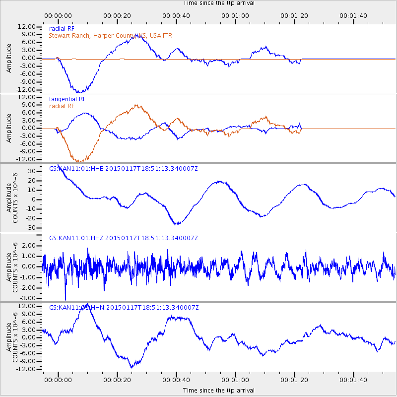
KAN11 Stewart Ranch, Harper County, KS, USA - Earthquake Result Viewer
*The percent match for this event was below the threshold and hence no stack was calculated.
| Earthquake location: |
Salta Province, Argentina |
| Earthquake latitude/longitude: |
-22.2/-63.1 |
| Earthquake time(UTC): |
2015/01/17 (017) 18:41:42 GMT |
| Earthquake Depth: |
557 km |
| Earthquake Magnitude: |
5.6 MWW, 5.6 MWB |
| Earthquake Catalog/Contributor: |
NEIC PDE/NEIC COMCAT |
|
| Network: |
GS US Geological Survey Networks |
| Station: |
KAN11 Stewart Ranch, Harper County, KS, USA |
| Lat/Lon: |
37.21 N/97.91 W |
| Elevation: |
410 m |
|
| Distance: |
67.6 deg |
| Az: |
330.497 deg |
| Baz: |
145.147 deg |
| Ray Param: |
$rayparam |
*The percent match for this event was below the threshold and hence was not used in the summary stack. |
|
| Radial Match: |
46.658737 % |
| Radial Bump: |
400 |
| Transverse Match: |
23.929234 % |
| Transverse Bump: |
400 |
| SOD ConfigId: |
872571 |
| Insert Time: |
2015-02-24 18:01:58.703 +0000 |
| GWidth: |
2.5 |
| Max Bumps: |
400 |
| Tol: |
0.001 |
|
Signal To Noise
| Channel | StoN | STA | LTA |
| GS:KAN11:01:HHZ:20150117T18:51:13.340007Z | 1.6241717 | 8.5077323E-7 | 5.238197E-7 |
| GS:KAN11:01:HHN:20150117T18:51:13.340007Z | 1.5396174 | 7.922378E-6 | 5.14568E-6 |
| GS:KAN11:01:HHE:20150117T18:51:13.340007Z | 0.5274127 | 6.1584137E-6 | 1.167665E-5 |
| Arrivals |
| Ps | |
| PpPs | |
| PsPs/PpSs | |


