You are here: Home > Network List > N4 - Central and EAstern US Network Stations List
> Station X58A Rowland, NC, USA > Earthquake Result Viewer
X58A Rowland, NC, USA - Earthquake Result Viewer
| Earthquake location: |
Southern Alaska |
| Earthquake latitude/longitude: |
61.7/-152.0 |
| Earthquake time(UTC): |
2015/06/24 (175) 22:32:20 GMT |
| Earthquake Depth: |
105 km |
| Earthquake Magnitude: |
5.7 MB, 6.2 MB |
| Earthquake Catalog/Contributor: |
NEIC PDE/NEIC ALERT |
|
| Network: |
N4 Central and EAstern US Network |
| Station: |
X58A Rowland, NC, USA |
| Lat/Lon: |
34.55 N/79.34 W |
| Elevation: |
45 m |
|
| Distance: |
52.1 deg |
| Az: |
86.193 deg |
| Baz: |
324.87 deg |
| Ray Param: |
0.066618085 |
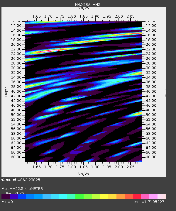
| Estimated Moho Depth: |
22.5 km |
| Estimated Crust Vp/Vs: |
1.70 |
| Assumed Crust Vp: |
6.565 km/s |
| Estimated Crust Vs: |
3.856 km/s |
| Estimated Crust Poisson's Ratio: |
0.24 |
|
| Radial Match: |
86.123825 % |
| Radial Bump: |
400 |
| Transverse Match: |
62.399677 % |
| Transverse Bump: |
400 |
| SOD ConfigId: |
7422571 |
| Insert Time: |
2019-04-19 11:22:24.316 +0000 |
| GWidth: |
2.5 |
| Max Bumps: |
400 |
| Tol: |
0.001 |
|

Signal To Noise
| Channel | StoN | STA | LTA |
| N4:X58A: :HHZ:20150624T22:40:48.089996Z | 7.927657 | 9.2210917E-7 | 1.16315476E-7 |
| N4:X58A: :HHN:20150624T22:40:48.089996Z | 9.648624 | 1.1731485E-6 | 1.2158712E-7 |
| N4:X58A: :HHE:20150624T22:40:48.089996Z | 8.17871 | 1.0521022E-6 | 1.2863916E-7 |
| Arrivals |
| Ps | 2.6 SECOND |
| PpPs | 8.7 SECOND |
| PsPs/PpSs | 11 SECOND |


