You are here: Home > Network List > IU - Global Seismograph Network (GSN - IRIS/USGS) Stations List
> Station MIDW Midway Island, USA > Earthquake Result Viewer
MIDW Midway Island, USA - Earthquake Result Viewer

| Earthquake location: |
Northern Molucca Sea |
| Earthquake latitude/longitude: |
1.4/125.8 |
| Earthquake time(UTC): |
2007/04/02 (092) 19:42:56 GMT |
| Earthquake Depth: |
55 km |
| Earthquake Magnitude: |
5.8 MB |
| Earthquake Catalog/Contributor: |
WHDF/NEIC |
|
| Network: |
IU Global Seismograph Network (GSN - IRIS/USGS) |
| Station: |
MIDW Midway Island, USA |
| Lat/Lon: |
28.22 N/177.37 W |
| Elevation: |
18 m |
|
| Distance: |
60.4 deg |
| Az: |
58.188 deg |
| Baz: |
254.292 deg |
| Ray Param: |
0.061416205 |
| Estimated Moho Depth: |
61.25 km |
| Estimated Crust Vp/Vs: |
2.08 |
| Assumed Crust Vp: |
4.24 km/s |
| Estimated Crust Vs: |
2.041 km/s |
| Estimated Crust Poisson's Ratio: |
0.35 |
|
| Radial Match: |
99.93575 % |
| Radial Bump: |
17 |
| Transverse Match: |
99.55762 % |
| Transverse Bump: |
34 |
| SOD ConfigId: |
2564 |
| Insert Time: |
2010-03-03 15:10:56.228 +0000 |
| GWidth: |
2.5 |
| Max Bumps: |
400 |
| Tol: |
0.001 |
|
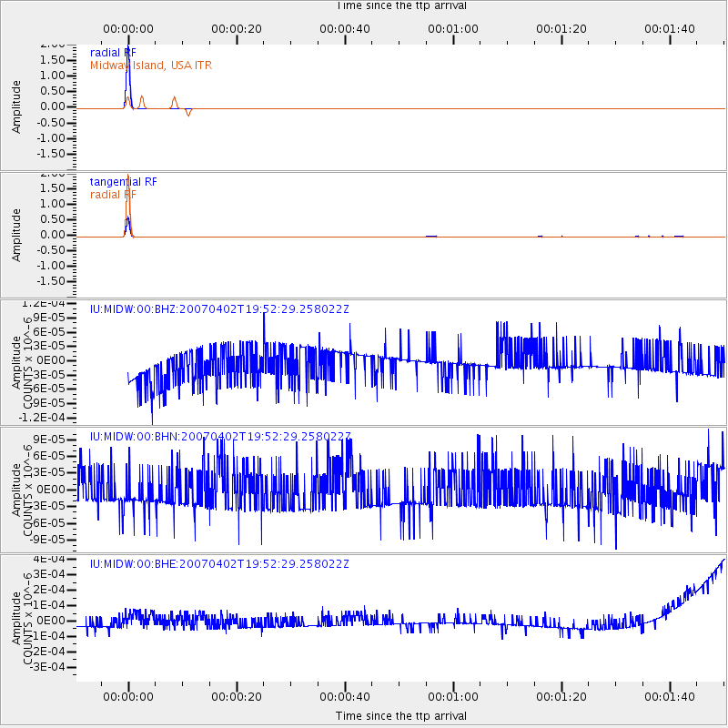
Signal To Noise
| Channel | StoN | STA | LTA |
| IU:MIDW:00:BHN:20070402T19:52:29.258022Z | 0.9642336 | 3.1165334E-11 | 3.2321354E-11 |
| IU:MIDW:00:BHE:20070402T19:52:29.258022Z | 1.4963948 | 7.737967E-11 | 5.1710736E-11 |
| IU:MIDW:00:BHZ:20070402T19:52:29.258022Z | 1.1062845 | 3.9139417E-11 | 3.537916E-11 |
| Arrivals |
| Ps | 16 SECOND |
| PpPs | 44 SECOND |
| PsPs/PpSs | 60 SECOND |


