You are here: Home > Network List > IU - Global Seismograph Network (GSN - IRIS/USGS) Stations List
> Station MIDW Midway Island, USA > Earthquake Result Viewer
MIDW Midway Island, USA - Earthquake Result Viewer
| Earthquake location: |
Mindanao, Philippines |
| Earthquake latitude/longitude: |
9.2/126.1 |
| Earthquake time(UTC): |
2007/03/20 (079) 03:10:30 GMT |
| Earthquake Depth: |
35 km |
| Earthquake Magnitude: |
5.5 MB, 4.9 MS, 5.5 MW, 5.4 MW |
| Earthquake Catalog/Contributor: |
WHDF/NEIC |
|
| Network: |
IU Global Seismograph Network (GSN - IRIS/USGS) |
| Station: |
MIDW Midway Island, USA |
| Lat/Lon: |
28.22 N/177.37 W |
| Elevation: |
18 m |
|
| Distance: |
56.3 deg |
| Az: |
62.257 deg |
| Baz: |
261.967 deg |
| Ray Param: |
0.0641935 |
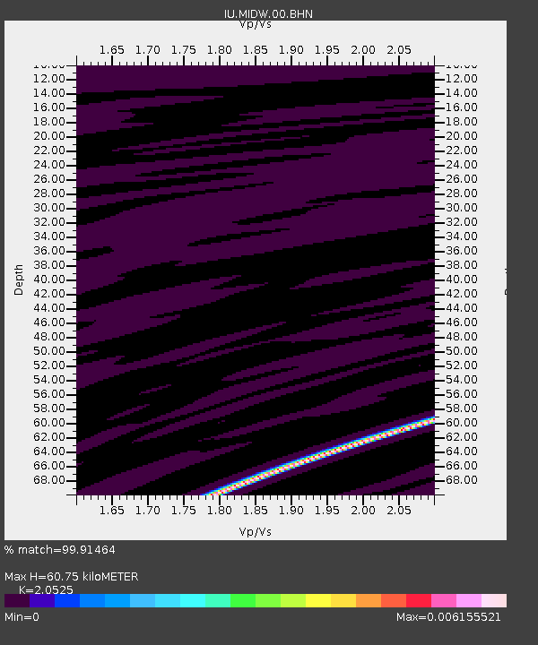
| Estimated Moho Depth: |
60.75 km |
| Estimated Crust Vp/Vs: |
2.05 |
| Assumed Crust Vp: |
4.24 km/s |
| Estimated Crust Vs: |
2.066 km/s |
| Estimated Crust Poisson's Ratio: |
0.34 |
|
| Radial Match: |
99.91464 % |
| Radial Bump: |
15 |
| Transverse Match: |
98.911766 % |
| Transverse Bump: |
71 |
| SOD ConfigId: |
2564 |
| Insert Time: |
2010-03-03 15:11:04.866 +0000 |
| GWidth: |
2.5 |
| Max Bumps: |
400 |
| Tol: |
0.001 |
|

Signal To Noise
| Channel | StoN | STA | LTA |
| IU:MIDW:00:BHN:20070320T03:19:36.709014Z | 1.2354622 | 5.212405E-11 | 4.218992E-11 |
| IU:MIDW:00:BHE:20070320T03:19:36.709014Z | 1.2007246 | 5.6850386E-11 | 4.734673E-11 |
| IU:MIDW:00:BHZ:20070320T03:19:36.709014Z | 1.2529128 | 3.7165916E-11 | 2.9663612E-11 |
| Arrivals |
| Ps | 15 SECOND |
| PpPs | 43 SECOND |
| PsPs/PpSs | 58 SECOND |


