You are here: Home > Network List > IU - Global Seismograph Network (GSN - IRIS/USGS) Stations List
> Station MIDW Midway Island, USA > Earthquake Result Viewer
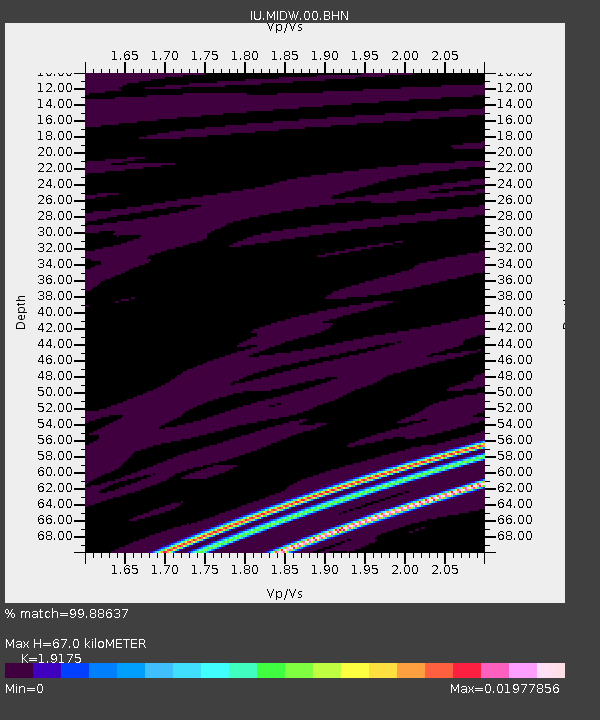
MIDW Midway Island, USA - Earthquake Result Viewer
| Earthquake location: |
Northern Sumatra, Indonesia |
| Earthquake latitude/longitude: |
3.8/96.3 |
| Earthquake time(UTC): |
2007/03/01 (060) 02:01:07 GMT |
| Earthquake Depth: |
74 km |
| Earthquake Magnitude: |
5.6 MB |
| Earthquake Catalog/Contributor: |
WHDF/NEIC |
|
| Network: |
IU Global Seismograph Network (GSN - IRIS/USGS) |
| Station: |
MIDW Midway Island, USA |
| Lat/Lon: |
28.22 N/177.37 W |
| Elevation: |
18 m |
|
| Distance: |
85.0 deg |
| Az: |
62.135 deg |
| Baz: |
271.576 deg |
| Ray Param: |
0.04495332 |
| Estimated Moho Depth: |
67.0 km |
| Estimated Crust Vp/Vs: |
1.92 |
| Assumed Crust Vp: |
4.24 km/s |
| Estimated Crust Vs: |
2.211 km/s |
| Estimated Crust Poisson's Ratio: |
0.31 |
|
| Radial Match: |
99.88637 % |
| Radial Bump: |
23 |
| Transverse Match: |
26.337095 % |
| Transverse Bump: |
238 |
| SOD ConfigId: |
2564 |
| Insert Time: |
2010-03-03 15:11:12.954 +0000 |
| GWidth: |
2.5 |
| Max Bumps: |
400 |
| Tol: |
0.001 |
|

Signal To Noise
| Channel | StoN | STA | LTA |
| IU:MIDW:00:BHN:20070301T02:13:02.958008Z | 0.97079307 | 3.7794143E-11 | 3.8931205E-11 |
| IU:MIDW:00:BHE:20070301T02:13:02.958008Z | 1.0403363 | 4.3510594E-11 | 4.1823586E-11 |
| IU:MIDW:00:BHZ:20070301T02:13:02.958008Z | 0.9393877 | 4.974868E-11 | 5.2958627E-11 |
| Arrivals |
| Ps | 15 SECOND |
| PpPs | 46 SECOND |
| PsPs/PpSs | 60 SECOND |


