You are here: Home > Network List > IU - Global Seismograph Network (GSN - IRIS/USGS) Stations List
> Station MIDW Midway Island, USA > Earthquake Result Viewer
MIDW Midway Island, USA - Earthquake Result Viewer

| Earthquake location: |
Southern Molucca Sea |
| Earthquake latitude/longitude: |
-0.4/124.2 |
| Earthquake time(UTC): |
2007/02/13 (044) 19:22:14 GMT |
| Earthquake Depth: |
85 km |
| Earthquake Magnitude: |
5.5 MB, 5.5 MW, 5.4 MW |
| Earthquake Catalog/Contributor: |
WHDF/NEIC |
|
| Network: |
IU Global Seismograph Network (GSN - IRIS/USGS) |
| Station: |
MIDW Midway Island, USA |
| Lat/Lon: |
28.22 N/177.37 W |
| Elevation: |
18 m |
|
| Distance: |
62.7 deg |
| Az: |
57.785 deg |
| Baz: |
253.472 deg |
| Ray Param: |
0.059818186 |
| Estimated Moho Depth: |
69.5 km |
| Estimated Crust Vp/Vs: |
2.07 |
| Assumed Crust Vp: |
4.24 km/s |
| Estimated Crust Vs: |
2.048 km/s |
| Estimated Crust Poisson's Ratio: |
0.35 |
|
| Radial Match: |
99.900185 % |
| Radial Bump: |
16 |
| Transverse Match: |
99.30967 % |
| Transverse Bump: |
38 |
| SOD ConfigId: |
2564 |
| Insert Time: |
2010-03-03 15:11:16.951 +0000 |
| GWidth: |
2.5 |
| Max Bumps: |
400 |
| Tol: |
0.001 |
|
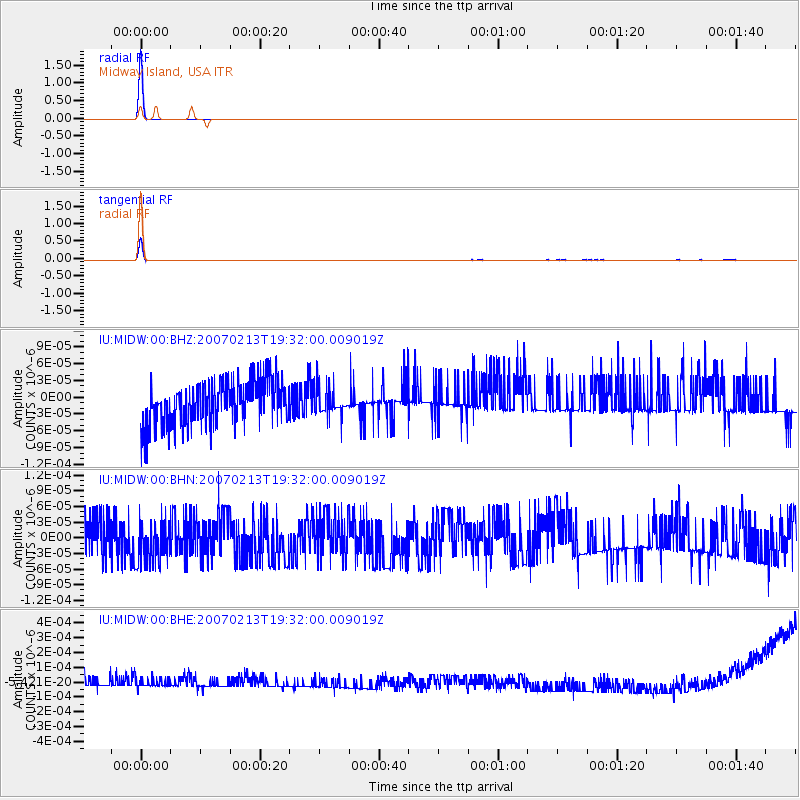
Signal To Noise
| Channel | StoN | STA | LTA |
| IU:MIDW:00:BHN:20070213T19:32:00.009019Z | 0.9793565 | 4.082569E-11 | 4.1686238E-11 |
| IU:MIDW:00:BHE:20070213T19:32:00.009019Z | 0.8190855 | 3.6491532E-11 | 4.4551557E-11 |
| IU:MIDW:00:BHZ:20070213T19:32:00.009019Z | 0.5795271 | 2.3233339E-11 | 4.009017E-11 |
| Arrivals |
| Ps | 18 SECOND |
| PpPs | 50 SECOND |
| PsPs/PpSs | 67 SECOND |


