You are here: Home > Network List > IU - Global Seismograph Network (GSN - IRIS/USGS) Stations List
> Station MIDW Midway Island, USA > Earthquake Result Viewer
MIDW Midway Island, USA - Earthquake Result Viewer
| Earthquake location: |
Northern Molucca Sea |
| Earthquake latitude/longitude: |
1.2/126.3 |
| Earthquake time(UTC): |
2007/02/01 (032) 10:43:26 GMT |
| Earthquake Depth: |
10 km |
| Earthquake Magnitude: |
5.5 MB, 4.8 MS |
| Earthquake Catalog/Contributor: |
WHDF/NEIC |
|
| Network: |
IU Global Seismograph Network (GSN - IRIS/USGS) |
| Station: |
MIDW Midway Island, USA |
| Lat/Lon: |
28.22 N/177.37 W |
| Elevation: |
18 m |
|
| Distance: |
60.0 deg |
| Az: |
57.934 deg |
| Baz: |
253.753 deg |
| Ray Param: |
0.061805632 |
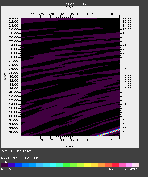
| Estimated Moho Depth: |
67.75 km |
| Estimated Crust Vp/Vs: |
2.06 |
| Assumed Crust Vp: |
4.24 km/s |
| Estimated Crust Vs: |
2.058 km/s |
| Estimated Crust Poisson's Ratio: |
0.35 |
|
| Radial Match: |
99.89304 % |
| Radial Bump: |
15 |
| Transverse Match: |
99.59985 % |
| Transverse Bump: |
36 |
| SOD ConfigId: |
2564 |
| Insert Time: |
2010-03-03 15:11:19.624 +0000 |
| GWidth: |
2.5 |
| Max Bumps: |
400 |
| Tol: |
0.001 |
|

Signal To Noise
| Channel | StoN | STA | LTA |
| IU:MIDW:00:BHN:20070201T10:53:02.409026Z | 0.8636654 | 3.1785536E-11 | 3.6803068E-11 |
| IU:MIDW:00:BHE:20070201T10:53:02.409026Z | 0.9413308 | 5.0484315E-11 | 5.3630787E-11 |
| IU:MIDW:00:BHZ:20070201T10:53:02.409026Z | 1.7877326 | 5.1430263E-11 | 2.876843E-11 |
| Arrivals |
| Ps | 17 SECOND |
| PpPs | 48 SECOND |
| PsPs/PpSs | 65 SECOND |


