You are here: Home > Network List > IU - Global Seismograph Network (GSN - IRIS/USGS) Stations List
> Station MIDW Midway Island, USA > Earthquake Result Viewer
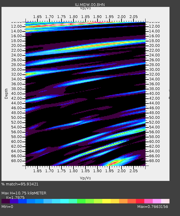
MIDW Midway Island, USA - Earthquake Result Viewer
| Earthquake location: |
Tonga Islands Region |
| Earthquake latitude/longitude: |
-23.0/-174.7 |
| Earthquake time(UTC): |
2009/03/19 (078) 18:17:40 GMT |
| Earthquake Depth: |
34 km |
| Earthquake Magnitude: |
7.0 MB, 7.6 MS, 7.6 MW, 7.6 MW |
| Earthquake Catalog/Contributor: |
WHDF/NEIC |
|
| Network: |
IU Global Seismograph Network (GSN - IRIS/USGS) |
| Station: |
MIDW Midway Island, USA |
| Lat/Lon: |
28.22 N/177.37 W |
| Elevation: |
18 m |
|
| Distance: |
51.0 deg |
| Az: |
356.923 deg |
| Baz: |
176.788 deg |
| Ray Param: |
0.067606 |
| Estimated Moho Depth: |
10.75 km |
| Estimated Crust Vp/Vs: |
1.79 |
| Assumed Crust Vp: |
4.24 km/s |
| Estimated Crust Vs: |
2.372 km/s |
| Estimated Crust Poisson's Ratio: |
0.27 |
|
| Radial Match: |
95.93421 % |
| Radial Bump: |
399 |
| Transverse Match: |
83.883804 % |
| Transverse Bump: |
400 |
| SOD ConfigId: |
2658 |
| Insert Time: |
2010-03-03 15:11:27.589 +0000 |
| GWidth: |
2.5 |
| Max Bumps: |
400 |
| Tol: |
0.001 |
|

Signal To Noise
| Channel | StoN | STA | LTA |
| IU:MIDW:00:BHN:20090319T18:26:09.048Z | 12.128639 | 7.3461583E-6 | 6.056869E-7 |
| IU:MIDW:00:BHE:20090319T18:26:09.048Z | 3.8862646 | 5.1930238E-6 | 1.3362508E-6 |
| IU:MIDW:00:BHZ:20090319T18:26:09.048Z | 1.2336414 | 1.5151054E-6 | 1.2281571E-6 |
| Arrivals |
| Ps | 2.0 SECOND |
| PpPs | 6.9 SECOND |
| PsPs/PpSs | 8.9 SECOND |


