You are here: Home > Network List > IU - Global Seismograph Network (GSN - IRIS/USGS) Stations List
> Station MIDW Midway Island, USA > Earthquake Result Viewer
MIDW Midway Island, USA - Earthquake Result Viewer
| Earthquake location: |
Kermadec Islands Region |
| Earthquake latitude/longitude: |
-31.8/-179.3 |
| Earthquake time(UTC): |
2006/05/16 (136) 10:39:23 GMT |
| Earthquake Depth: |
152 km |
| Earthquake Magnitude: |
6.8 MB, 7.4 MW, 7.4 MW |
| Earthquake Catalog/Contributor: |
WHDF/NEIC |
|
| Network: |
IU Global Seismograph Network (GSN - IRIS/USGS) |
| Station: |
MIDW Midway Island, USA |
| Lat/Lon: |
28.22 N/177.37 W |
| Elevation: |
18 m |
|
| Distance: |
59.7 deg |
| Az: |
1.986 deg |
| Baz: |
181.917 deg |
| Ray Param: |
0.061554 |
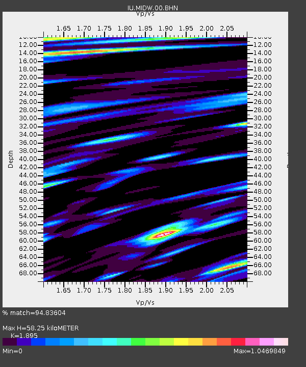
| Estimated Moho Depth: |
58.25 km |
| Estimated Crust Vp/Vs: |
1.89 |
| Assumed Crust Vp: |
4.24 km/s |
| Estimated Crust Vs: |
2.237 km/s |
| Estimated Crust Poisson's Ratio: |
0.31 |
|
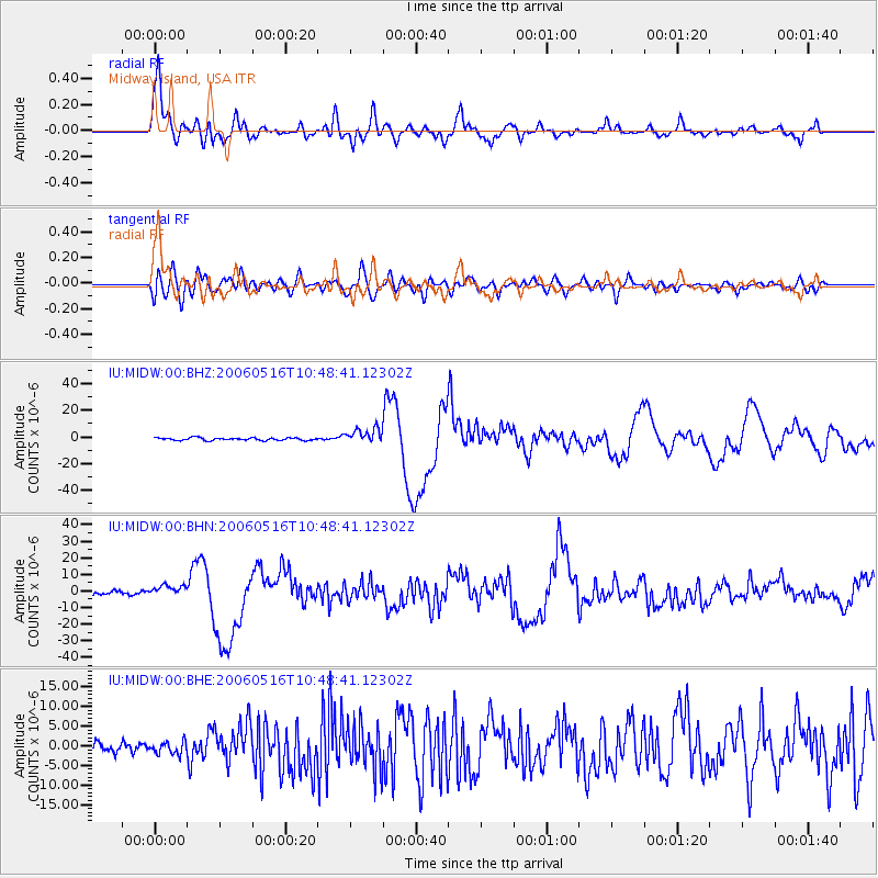
| Radial Match: |
94.83604 % |
| Radial Bump: |
400 |
| Transverse Match: |
80.11308 % |
| Transverse Bump: |
400 |
| SOD ConfigId: |
2669 |
| Insert Time: |
2010-03-03 15:11:30.397 +0000 |
| GWidth: |
2.5 |
| Max Bumps: |
400 |
| Tol: |
0.001 |
|
Signal To Noise
| Channel | StoN | STA | LTA |
| IU:MIDW:00:BHN:20060516T10:48:41.12302Z | 2.4588766 | 3.3916044E-6 | 1.3793308E-6 |
| IU:MIDW:00:BHE:20060516T10:48:41.12302Z | 1.3102081 | 1.5506201E-6 | 1.1834915E-6 |
| IU:MIDW:00:BHZ:20060516T10:48:41.12302Z | 5.7848988 | 5.7038847E-6 | 9.859956E-7 |
| Arrivals |
| Ps | 13 SECOND |
| PpPs | 39 SECOND |
| PsPs/PpSs | 52 SECOND |


