You are here: Home > Network List > IU - Global Seismograph Network (GSN - IRIS/USGS) Stations List
> Station MIDW Midway Island, USA > Earthquake Result Viewer
MIDW Midway Island, USA - Earthquake Result Viewer

| Earthquake location: |
Tonga Islands |
| Earthquake latitude/longitude: |
-20.2/-174.1 |
| Earthquake time(UTC): |
2006/05/03 (123) 15:26:40 GMT |
| Earthquake Depth: |
55 km |
| Earthquake Magnitude: |
7.2 MB, 7.8 MS, 7.9 MW, 7.9 MW |
| Earthquake Catalog/Contributor: |
WHDF/NEIC |
|
| Network: |
IU Global Seismograph Network (GSN - IRIS/USGS) |
| Station: |
MIDW Midway Island, USA |
| Lat/Lon: |
28.22 N/177.37 W |
| Elevation: |
18 m |
|
| Distance: |
48.2 deg |
| Az: |
356.157 deg |
| Baz: |
175.909 deg |
| Ray Param: |
0.06935287 |
| Estimated Moho Depth: |
64.0 km |
| Estimated Crust Vp/Vs: |
1.88 |
| Assumed Crust Vp: |
4.24 km/s |
| Estimated Crust Vs: |
2.261 km/s |
| Estimated Crust Poisson's Ratio: |
0.30 |
|
| Radial Match: |
96.92515 % |
| Radial Bump: |
400 |
| Transverse Match: |
83.63723 % |
| Transverse Bump: |
400 |
| SOD ConfigId: |
2669 |
| Insert Time: |
2010-03-03 15:11:31.451 +0000 |
| GWidth: |
2.5 |
| Max Bumps: |
400 |
| Tol: |
0.001 |
|
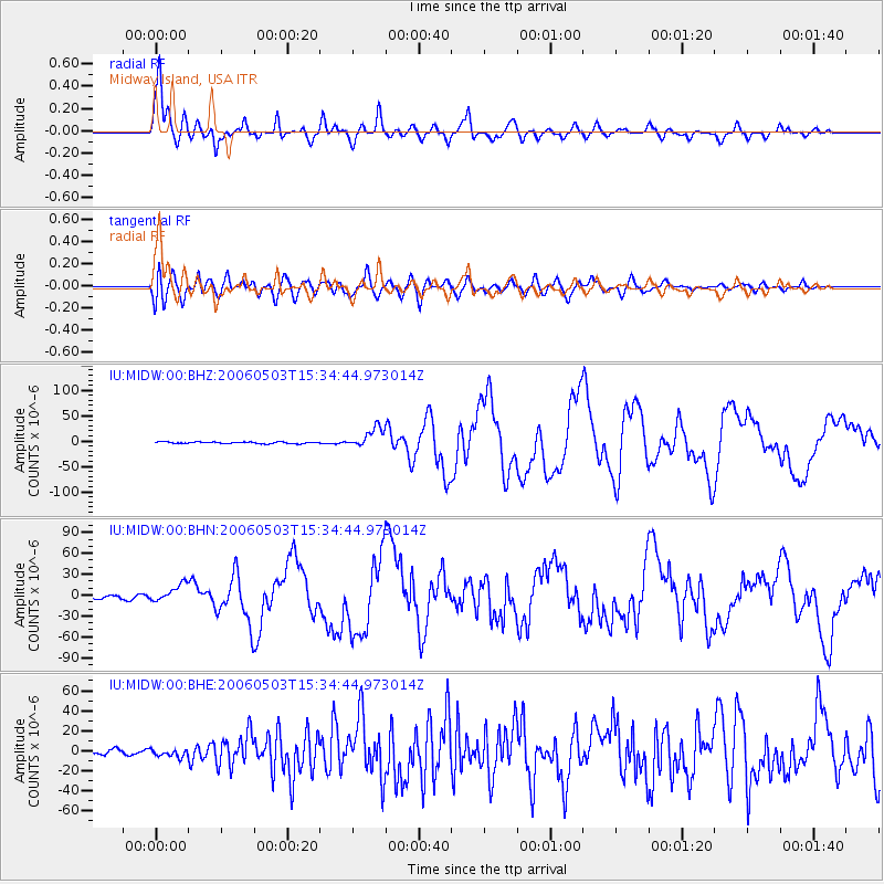
Signal To Noise
| Channel | StoN | STA | LTA |
| IU:MIDW:00:BHN:20060503T15:34:44.973014Z | 5.2823462 | 1.2694864E-5 | 2.4032624E-6 |
| IU:MIDW:00:BHE:20060503T15:34:44.973014Z | 1.6600306 | 3.8832786E-6 | 2.3392813E-6 |
| IU:MIDW:00:BHZ:20060503T15:34:44.973014Z | 11.320843 | 1.9582088E-5 | 1.7297378E-6 |
| Arrivals |
| Ps | 14 SECOND |
| PpPs | 42 SECOND |
| PsPs/PpSs | 56 SECOND |


