You are here: Home > Network List > CI - Caltech Regional Seismic Network Stations List
> Station MPM Manuel Prospect Mine, California, USA > Earthquake Result Viewer
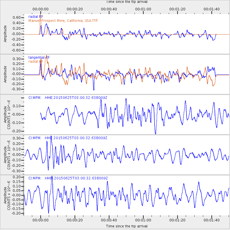
MPM Manuel Prospect Mine, California, USA - Earthquake Result Viewer
*The percent match for this event was below the threshold and hence no stack was calculated.
| Earthquake location: |
Panama-Costa Rica Border Region |
| Earthquake latitude/longitude: |
8.2/-82.8 |
| Earthquake time(UTC): |
2015/06/25 (176) 02:53:11 GMT |
| Earthquake Depth: |
8.4 km |
| Earthquake Magnitude: |
4.8 MW, 5.0 mb, 4.1 MS |
| Earthquake Catalog/Contributor: |
ISC/ISC |
|
| Network: |
CI Caltech Regional Seismic Network |
| Station: |
MPM Manuel Prospect Mine, California, USA |
| Lat/Lon: |
36.06 N/117.49 W |
| Elevation: |
185 m |
|
| Distance: |
42.0 deg |
| Az: |
316.451 deg |
| Baz: |
122.687 deg |
| Ray Param: |
$rayparam |
*The percent match for this event was below the threshold and hence was not used in the summary stack. |
|
| Radial Match: |
63.601242 % |
| Radial Bump: |
400 |
| Transverse Match: |
57.003677 % |
| Transverse Bump: |
400 |
| SOD ConfigId: |
7422571 |
| Insert Time: |
2019-04-19 11:29:20.445 +0000 |
| GWidth: |
2.5 |
| Max Bumps: |
400 |
| Tol: |
0.001 |
|
Signal To Noise
| Channel | StoN | STA | LTA |
| CI:MPM: :HHZ:20150625T03:00:32.638009Z | 2.0008025 | 1.339663E-7 | 6.6956275E-8 |
| CI:MPM: :HHN:20150625T03:00:32.638009Z | 2.1120386 | 9.319121E-8 | 4.412382E-8 |
| CI:MPM: :HHE:20150625T03:00:32.638009Z | 1.0181618 | 5.4022365E-8 | 5.3058724E-8 |
| Arrivals |
| Ps | |
| PpPs | |
| PsPs/PpSs | |


