You are here: Home > Network List > UU - University of Utah Regional Network Stations List
> Station CCUT Cedar City, UT, USA > Earthquake Result Viewer
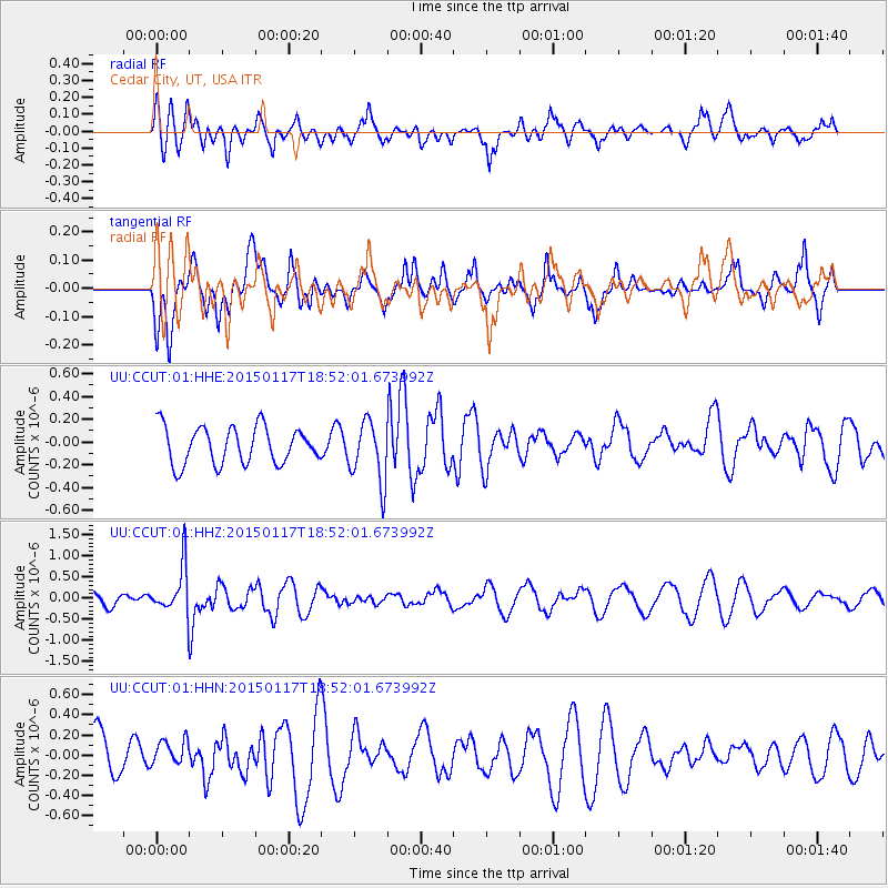
CCUT Cedar City, UT, USA - Earthquake Result Viewer
*The percent match for this event was below the threshold and hence no stack was calculated.
| Earthquake location: |
Salta Province, Argentina |
| Earthquake latitude/longitude: |
-22.2/-63.1 |
| Earthquake time(UTC): |
2015/01/17 (017) 18:41:42 GMT |
| Earthquake Depth: |
557 km |
| Earthquake Magnitude: |
5.6 MWW, 5.6 MWB |
| Earthquake Catalog/Contributor: |
NEIC PDE/NEIC COMCAT |
|
| Network: |
UU University of Utah Regional Network |
| Station: |
CCUT Cedar City, UT, USA |
| Lat/Lon: |
37.55 N/113.36 W |
| Elevation: |
2127 m |
|
| Distance: |
75.9 deg |
| Az: |
320.978 deg |
| Baz: |
132.78 deg |
| Ray Param: |
$rayparam |
*The percent match for this event was below the threshold and hence was not used in the summary stack. |
|
| Radial Match: |
46.979584 % |
| Radial Bump: |
400 |
| Transverse Match: |
48.3675 % |
| Transverse Bump: |
349 |
| SOD ConfigId: |
872571 |
| Insert Time: |
2015-02-24 18:07:03.548 +0000 |
| GWidth: |
2.5 |
| Max Bumps: |
400 |
| Tol: |
0.001 |
|
Signal To Noise
| Channel | StoN | STA | LTA |
| UU:CCUT:01:HHZ:20150117T18:52:01.673992Z | 3.2956877 | 5.642095E-7 | 1.7119629E-7 |
| UU:CCUT:01:HHN:20150117T18:52:01.673992Z | 0.6104483 | 1.2913094E-7 | 2.115346E-7 |
| UU:CCUT:01:HHE:20150117T18:52:01.673992Z | 1.6563969 | 2.6883163E-7 | 1.6229905E-7 |
| Arrivals |
| Ps | |
| PpPs | |
| PsPs/PpSs | |


