You are here: Home > Network List > CI - Caltech Regional Seismic Network Stations List
> Station LRL Laurel Mtn Radio Fac, Ridgecrest, CA, USA > Earthquake Result Viewer
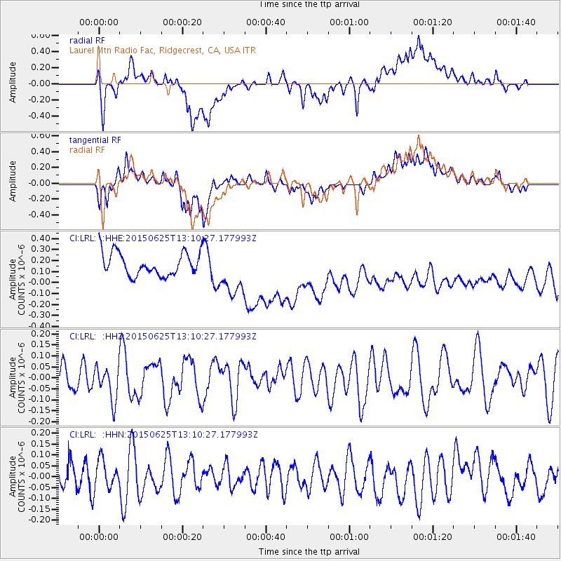
LRL Laurel Mtn Radio Fac, Ridgecrest, CA, USA - Earthquake Result Viewer
*The percent match for this event was below the threshold and hence no stack was calculated.
| Earthquake location: |
Tonga Islands |
| Earthquake latitude/longitude: |
-21.6/-173.8 |
| Earthquake time(UTC): |
2015/06/25 (176) 12:59:00 GMT |
| Earthquake Depth: |
7.7 km |
| Earthquake Magnitude: |
4.9 MW, 5.3 mb, 4.4 MS |
| Earthquake Catalog/Contributor: |
ISC/ISC |
|
| Network: |
CI Caltech Regional Seismic Network |
| Station: |
LRL Laurel Mtn Radio Fac, Ridgecrest, CA, USA |
| Lat/Lon: |
35.48 N/117.68 W |
| Elevation: |
1340 m |
|
| Distance: |
77.8 deg |
| Az: |
43.889 deg |
| Baz: |
232.212 deg |
| Ray Param: |
$rayparam |
*The percent match for this event was below the threshold and hence was not used in the summary stack. |
|
| Radial Match: |
36.851513 % |
| Radial Bump: |
400 |
| Transverse Match: |
37.701897 % |
| Transverse Bump: |
400 |
| SOD ConfigId: |
7422571 |
| Insert Time: |
2019-04-19 11:36:48.017 +0000 |
| GWidth: |
2.5 |
| Max Bumps: |
400 |
| Tol: |
0.001 |
|
Signal To Noise
| Channel | StoN | STA | LTA |
| CI:LRL: :HHZ:20150625T13:10:27.177993Z | 1.2971807 | 7.863412E-8 | 6.061925E-8 |
| CI:LRL: :HHN:20150625T13:10:27.177993Z | 1.0731068 | 6.3533726E-8 | 5.9205416E-8 |
| CI:LRL: :HHE:20150625T13:10:27.177993Z | 2.099921 | 2.1787372E-7 | 1.03753294E-7 |
| Arrivals |
| Ps | |
| PpPs | |
| PsPs/PpSs | |


