You are here: Home > Network List > GS - US Geological Survey Networks Stations List
> Station OK031 2598 S. Brethren Rd., Cushing, OK, USA > Earthquake Result Viewer
OK031 2598 S. Brethren Rd., Cushing, OK, USA - Earthquake Result Viewer
| Earthquake location: |
Tonga Islands |
| Earthquake latitude/longitude: |
-21.6/-173.8 |
| Earthquake time(UTC): |
2015/06/25 (176) 12:59:00 GMT |
| Earthquake Depth: |
7.7 km |
| Earthquake Magnitude: |
4.9 MW, 5.3 mb, 4.4 MS |
| Earthquake Catalog/Contributor: |
ISC/ISC |
|
| Network: |
GS US Geological Survey Networks |
| Station: |
OK031 2598 S. Brethren Rd., Cushing, OK, USA |
| Lat/Lon: |
35.95 N/96.84 W |
| Elevation: |
290 m |
|
| Distance: |
92.5 deg |
| Az: |
52.3 deg |
| Baz: |
245.132 deg |
| Ray Param: |
0.041442942 |
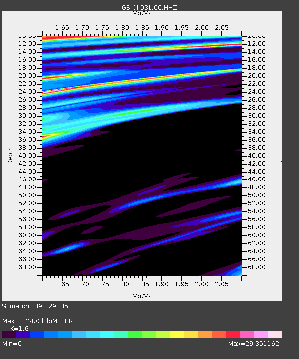
| Estimated Moho Depth: |
24.0 km |
| Estimated Crust Vp/Vs: |
1.60 |
| Assumed Crust Vp: |
6.426 km/s |
| Estimated Crust Vs: |
4.016 km/s |
| Estimated Crust Poisson's Ratio: |
0.18 |
|
| Radial Match: |
89.129135 % |
| Radial Bump: |
343 |
| Transverse Match: |
69.42352 % |
| Transverse Bump: |
400 |
| SOD ConfigId: |
7422571 |
| Insert Time: |
2019-04-19 11:37:32.023 +0000 |
| GWidth: |
2.5 |
| Max Bumps: |
400 |
| Tol: |
0.001 |
|

Signal To Noise
| Channel | StoN | STA | LTA |
| GS:OK031:00:HHZ:20150625T13:11:40.914016Z | 1.1983806 | 1.8757275E-7 | 1.5652186E-7 |
| GS:OK031:00:HH1:20150625T13:11:40.914016Z | 1.9232699 | 3.0992635E-6 | 1.6114553E-6 |
| GS:OK031:00:HH2:20150625T13:11:40.914016Z | 1.2926534 | 1.1374219E-5 | 8.799125E-6 |
| Arrivals |
| Ps | 2.3 SECOND |
| PpPs | 9.5 SECOND |
| PsPs/PpSs | 12 SECOND |


