You are here: Home > Network List > IU - Global Seismograph Network (GSN - IRIS/USGS) Stations List
> Station PMG Port Moresby, New Guinea > Earthquake Result Viewer
PMG Port Moresby, New Guinea - Earthquake Result Viewer
*The percent match for this event was below the threshold and hence no stack was calculated.
| Earthquake location: |
Rat Islands, Aleutian Islands |
| Earthquake latitude/longitude: |
52.2/178.1 |
| Earthquake time(UTC): |
2009/10/07 (280) 05:38:37 GMT |
| Earthquake Depth: |
138 km |
| Earthquake Magnitude: |
5.6 MB, 5.6 MW, 5.6 MW |
| Earthquake Catalog/Contributor: |
WHDF/NEIC |
|
| Network: |
IU Global Seismograph Network (GSN - IRIS/USGS) |
| Station: |
PMG Port Moresby, New Guinea |
| Lat/Lon: |
9.40 S/147.16 E |
| Elevation: |
90 m |
|
| Distance: |
66.8 deg |
| Az: |
213.446 deg |
| Baz: |
20.127 deg |
| Ray Param: |
$rayparam |
*The percent match for this event was below the threshold and hence was not used in the summary stack. |
|
| Radial Match: |
60.687424 % |
| Radial Bump: |
400 |
| Transverse Match: |
48.23869 % |
| Transverse Bump: |
400 |
| SOD ConfigId: |
1 |
| Insert Time: |
2010-02-19 00:32:20.904 +0000 |
| GWidth: |
2.5 |
| Max Bumps: |
400 |
| Tol: |
0.001 |
|
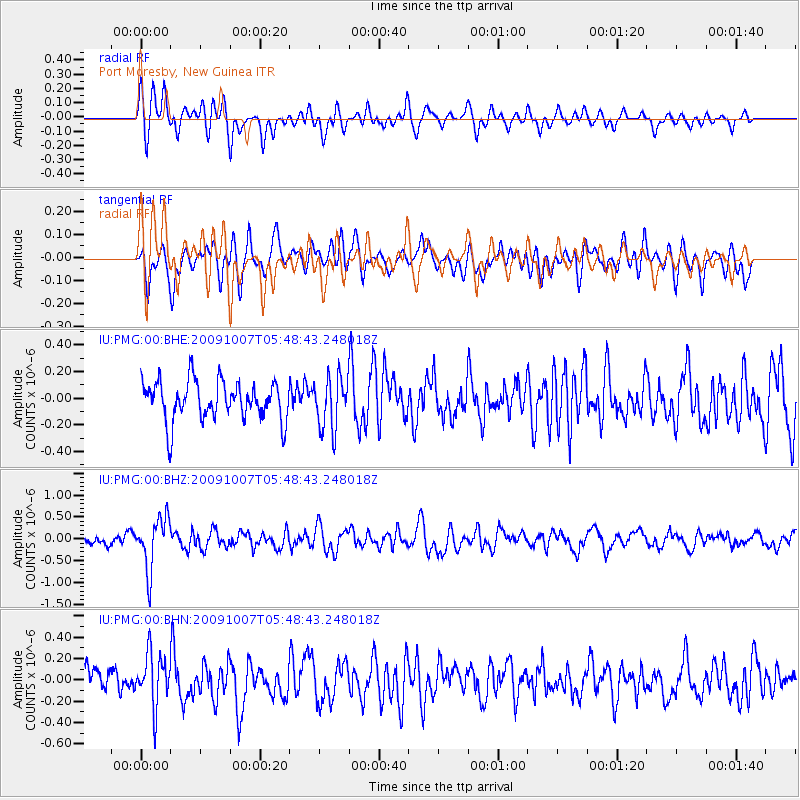
Signal To Noise
| Channel | StoN | STA | LTA |
| IU:PMG:00:BHZ:20091007T05:48:43.248018Z | 4.5028667 | 5.93672E-7 | 1.3184311E-7 |
| IU:PMG:00:BHN:20091007T05:48:43.248018Z | 2.0016575 | 2.5086996E-7 | 1.2533111E-7 |
| IU:PMG:00:BHE:20091007T05:48:43.248018Z | 1.3327931 | 1.9476636E-7 | 1.4613398E-7 |
| Arrivals |
| Ps | |
| PpPs | |
| PsPs/PpSs | |


