You are here: Home > Network List > CI - Caltech Regional Seismic Network Stations List
> Station SBC Santa Barbara, Santa Barbara, CA, USA > Earthquake Result Viewer
SBC Santa Barbara, Santa Barbara, CA, USA - Earthquake Result Viewer

| Earthquake location: |
Peru-Ecuador Border Region |
| Earthquake latitude/longitude: |
-2.3/-77.8 |
| Earthquake time(UTC): |
2007/11/16 (320) 03:13:00 GMT |
| Earthquake Depth: |
123 km |
| Earthquake Magnitude: |
6.3 MB, 6.8 MW, 6.7 MW |
| Earthquake Catalog/Contributor: |
WHDF/NEIC |
|
| Network: |
CI Caltech Regional Seismic Network |
| Station: |
SBC Santa Barbara, Santa Barbara, CA, USA |
| Lat/Lon: |
34.44 N/119.71 W |
| Elevation: |
94 m |
|
| Distance: |
53.7 deg |
| Az: |
316.784 deg |
| Baz: |
124.122 deg |
| Ray Param: |
0.065543726 |
| Estimated Moho Depth: |
47.25 km |
| Estimated Crust Vp/Vs: |
2.09 |
| Assumed Crust Vp: |
6.1 km/s |
| Estimated Crust Vs: |
2.915 km/s |
| Estimated Crust Poisson's Ratio: |
0.35 |
|
| Radial Match: |
82.86708 % |
| Radial Bump: |
400 |
| Transverse Match: |
73.947975 % |
| Transverse Bump: |
400 |
| SOD ConfigId: |
2564 |
| Insert Time: |
2010-02-25 21:35:04.437 +0000 |
| GWidth: |
2.5 |
| Max Bumps: |
400 |
| Tol: |
0.001 |
|
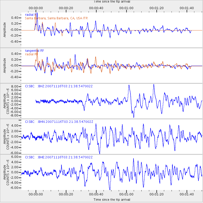
Signal To Noise
| Channel | StoN | STA | LTA |
| CI:SBC: :BHN:20071116T03:21:38.547002Z | 0.807493 | 4.576933E-7 | 5.668078E-7 |
| CI:SBC: :BHE:20071116T03:21:38.547002Z | 1.408676 | 8.158364E-7 | 5.7915116E-7 |
| CI:SBC: :BHZ:20071116T03:21:38.547002Z | 4.857952 | 2.265505E-6 | 4.6634983E-7 |
| Arrivals |
| Ps | 8.8 SECOND |
| PpPs | 23 SECOND |
| PsPs/PpSs | 32 SECOND |


