You are here: Home > Network List > IU - Global Seismograph Network (GSN - IRIS/USGS) Stations List
> Station BILL Bilibino, Russia > Earthquake Result Viewer
BILL Bilibino, Russia - Earthquake Result Viewer
| Earthquake location: |
Off Coast Of Oregon |
| Earthquake latitude/longitude: |
44.3/-129.0 |
| Earthquake time(UTC): |
2003/01/16 (016) 00:53:15 GMT |
| Earthquake Depth: |
10 km |
| Earthquake Magnitude: |
5.4 MB, 6.0 MS, 6.2 MW, 6.2 MW |
| Earthquake Catalog/Contributor: |
WHDF/NEIC |
|
| Network: |
IU Global Seismograph Network (GSN - IRIS/USGS) |
| Station: |
BILL Bilibino, Russia |
| Lat/Lon: |
68.07 N/166.45 E |
| Elevation: |
299 m |
|
| Distance: |
40.5 deg |
| Az: |
328.484 deg |
| Baz: |
92.197 deg |
| Ray Param: |
0.074391864 |
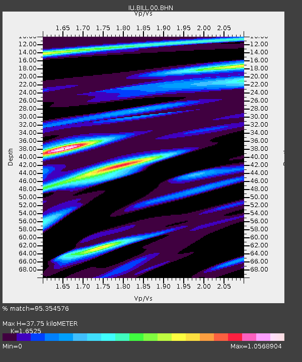
| Estimated Moho Depth: |
37.75 km |
| Estimated Crust Vp/Vs: |
1.65 |
| Assumed Crust Vp: |
6.577 km/s |
| Estimated Crust Vs: |
3.98 km/s |
| Estimated Crust Poisson's Ratio: |
0.21 |
|
| Radial Match: |
95.354576 % |
| Radial Bump: |
286 |
| Transverse Match: |
85.79861 % |
| Transverse Bump: |
400 |
| SOD ConfigId: |
4714 |
| Insert Time: |
2010-03-03 15:13:47.842 +0000 |
| GWidth: |
2.5 |
| Max Bumps: |
400 |
| Tol: |
0.001 |
|
Signal To Noise
| Channel | StoN | STA | LTA |
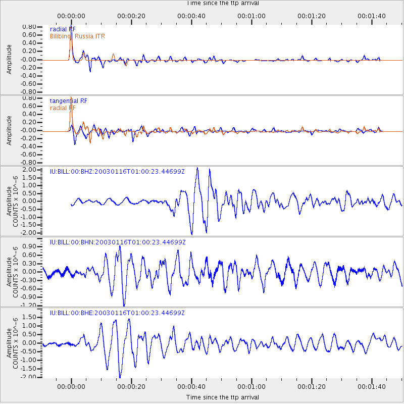
| IU:BILL:00:BHN:20030116T01:00:23.44699Z | 0.5849752 | 8.4151985E-8 | 1.4385564E-7 |
| IU:BILL:00:BHE:20030116T01:00:23.44699Z | 2.592592 | 2.2239956E-7 | 8.578271E-8 |
| IU:BILL:00:BHZ:20030116T01:00:23.44699Z | 2.8569868 | 3.6866442E-7 | 1.2903959E-7 |
| Arrivals |
| Ps | 4.1 SECOND |
| PpPs | 14 SECOND |
| PsPs/PpSs | 18 SECOND |


