You are here: Home > Network List > GS - US Geological Survey Networks Stations List
> Station KAN08 Pence Farm, Harper, KS, USA > Earthquake Result Viewer
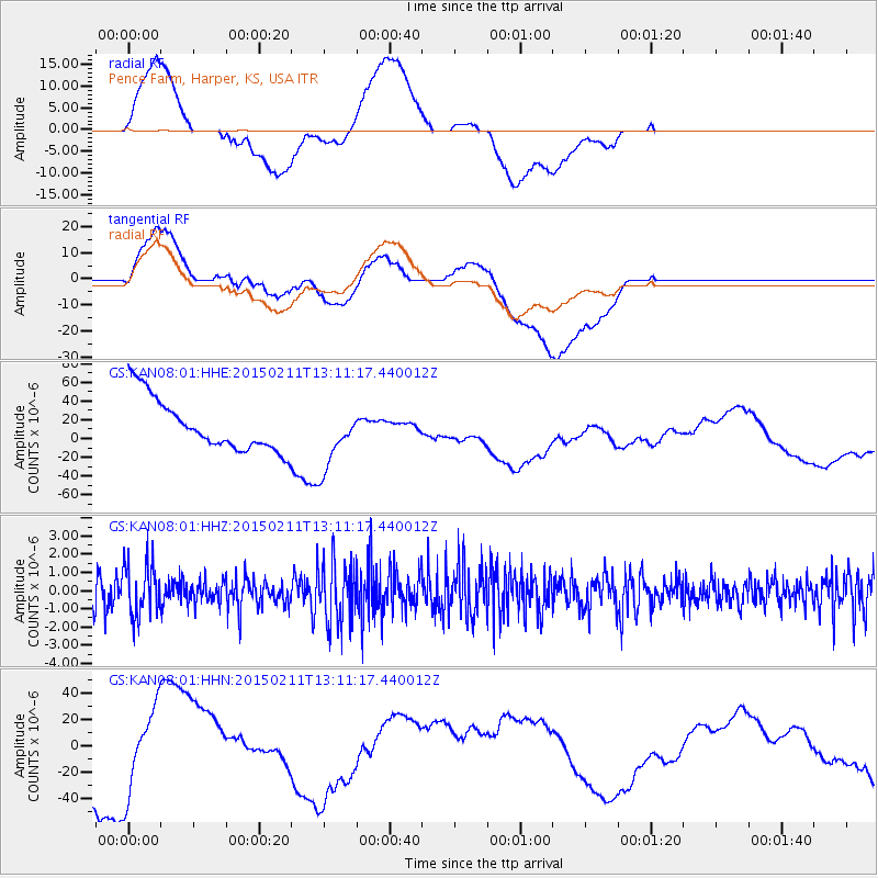
KAN08 Pence Farm, Harper, KS, USA - Earthquake Result Viewer
*The percent match for this event was below the threshold and hence no stack was calculated.
| Earthquake location: |
Jujuy Province, Argentina |
| Earthquake latitude/longitude: |
-23.5/-66.7 |
| Earthquake time(UTC): |
2015/02/11 (042) 13:01:15 GMT |
| Earthquake Depth: |
201 km |
| Earthquake Magnitude: |
5.5 MWW |
| Earthquake Catalog/Contributor: |
NEIC PDE/NEIC COMCAT |
|
| Network: |
GS US Geological Survey Networks |
| Station: |
KAN08 Pence Farm, Harper, KS, USA |
| Lat/Lon: |
37.23 N/97.97 W |
| Elevation: |
375 m |
|
| Distance: |
67.2 deg |
| Az: |
333.31 deg |
| Baz: |
148.907 deg |
| Ray Param: |
$rayparam |
*The percent match for this event was below the threshold and hence was not used in the summary stack. |
|
| Radial Match: |
48.677288 % |
| Radial Bump: |
400 |
| Transverse Match: |
32.625107 % |
| Transverse Bump: |
400 |
| SOD ConfigId: |
872571 |
| Insert Time: |
2015-02-25 13:11:10.786 +0000 |
| GWidth: |
2.5 |
| Max Bumps: |
400 |
| Tol: |
0.001 |
|
Signal To Noise
| Channel | StoN | STA | LTA |
| GS:KAN08:01:HHZ:20150211T13:11:17.440012Z | 1.6449767 | 1.4599328E-6 | 8.875097E-7 |
| GS:KAN08:01:HHN:20150211T13:11:17.440012Z | 0.70951676 | 3.6003596E-5 | 5.0743824E-5 |
| GS:KAN08:01:HHE:20150211T13:11:17.440012Z | 1.2003953 | 3.3292778E-5 | 2.7734844E-5 |
| Arrivals |
| Ps | |
| PpPs | |
| PsPs/PpSs | |


