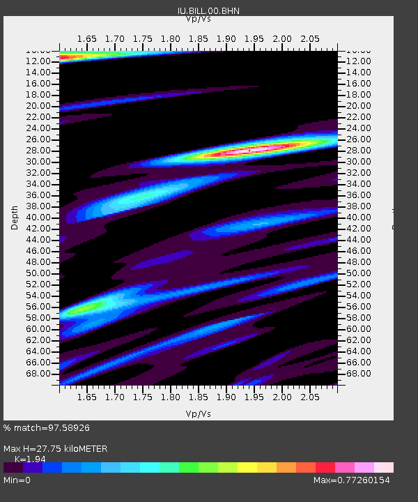
BILL Bilibino, Russia - Earthquake Result Viewer

Earthquake location: New Ireland Region, P.N.G.
Earthquake latitude/longitude: -3.6/150.7
Earthquake time(UTC): 2004/05/13 (134) 09:58:43 GMT
Earthquake Depth: 10 km
Earthquake Magnitude: 5.8 MB, 6.3 MS, 6.3 MW, 6.2 MW
Earthquake Catalog/Contributor: WHDF/NEIC
Network: IU Global Seismograph Network (GSN - IRIS/USGS)
Station: BILL Bilibino, Russia
Lat/Lon: 68.07 N/166.45 E
Elevation: 299 m
Distance: 72.3 deg
Az: 6.134 deg
Baz: 196.489 deg
Ray Param: 0.053727277
Estimated Moho Depth: 27.75 km
Estimated Crust Vp/Vs: 1.94
Assumed Crust Vp: 6.577 km/s
Estimated Crust Vs: 3.39 km/s
Estimated Crust Poisson's Ratio: 0.32
Radial Match: 97.58926 %
Radial Bump: 368
Transverse Match: 87.959816 %
Transverse Bump: 400
SOD ConfigId: 2459
Insert Time: 2010-03-03 15:14:11.485 +0000
GWidth: 2.5
Max Bumps: 400
Tol: 0.001

Signal To Noise

ChannelStoNSTALTA
IU:BILL:00:BHN:20040513T10:09:38.009021Z2.9763822.1112618E-77.093383E-8
IU:BILL:00:BHE:20040513T10:09:38.009021Z0.63710314.508408E-87.076419E-8
IU:BILL:00:BHZ:20040513T10:09:38.009021Z9.7020084.2576434E-74.3884143E-8
Arrivals
Ps4.1 SECOND
PpPs12 SECOND
PsPs/PpSs16 SECOND