You are here: Home > Network List > AV - Alaska Volcano Observatory Stations List
> Station AMKA Regional Station, Amchitka Island, Alaska > Earthquake Result Viewer
AMKA Regional Station, Amchitka Island, Alaska - Earthquake Result Viewer
| Earthquake location: |
South Of Kermadec Islands |
| Earthquake latitude/longitude: |
-32.0/-178.2 |
| Earthquake time(UTC): |
2015/06/25 (176) 18:45:58 GMT |
| Earthquake Depth: |
10 km |
| Earthquake Magnitude: |
5.8 MB |
| Earthquake Catalog/Contributor: |
NEIC PDE/NEIC ALERT |
|
| Network: |
AV Alaska Volcano Observatory |
| Station: |
AMKA Regional Station, Amchitka Island, Alaska |
| Lat/Lon: |
51.38 N/179.30 E |
| Elevation: |
116 m |
|
| Distance: |
83.1 deg |
| Az: |
358.419 deg |
| Baz: |
177.857 deg |
| Ray Param: |
0.04643329 |
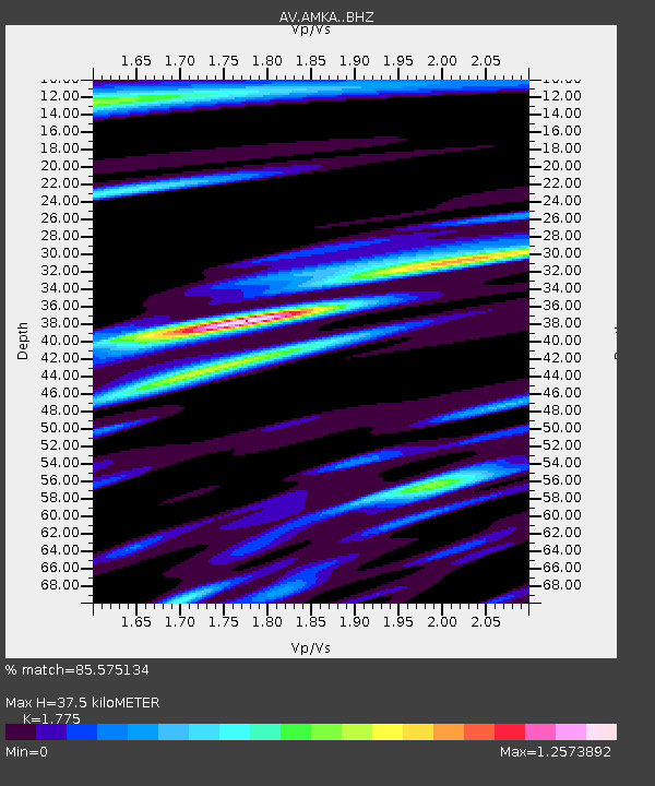
| Estimated Moho Depth: |
37.5 km |
| Estimated Crust Vp/Vs: |
1.77 |
| Assumed Crust Vp: |
6.183 km/s |
| Estimated Crust Vs: |
3.483 km/s |
| Estimated Crust Poisson's Ratio: |
0.27 |
|
| Radial Match: |
85.575134 % |
| Radial Bump: |
400 |
| Transverse Match: |
83.83231 % |
| Transverse Bump: |
400 |
| SOD ConfigId: |
7422571 |
| Insert Time: |
2019-04-19 11:52:45.815 +0000 |
| GWidth: |
2.5 |
| Max Bumps: |
400 |
| Tol: |
0.001 |
|
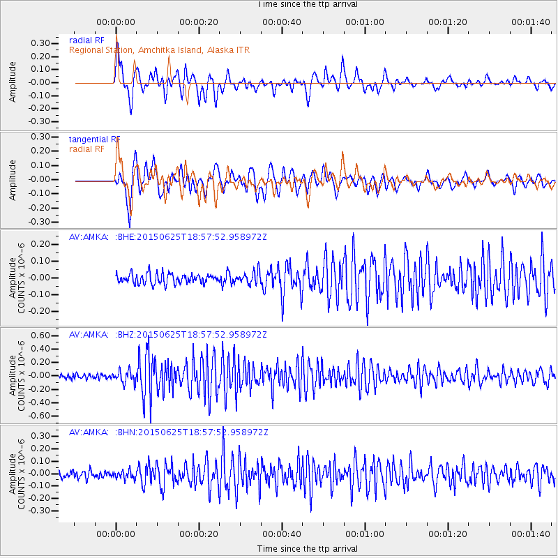
Signal To Noise
| Channel | StoN | STA | LTA |
| AV:AMKA: :BHZ:20150625T18:57:52.958972Z | 2.50403 | 8.786038E-8 | 3.508759E-8 |
| AV:AMKA: :BHN:20150625T18:57:52.958972Z | 1.0996518 | 3.078543E-8 | 2.7995615E-8 |
| AV:AMKA: :BHE:20150625T18:57:52.958972Z | 1.0730166 | 3.1011762E-8 | 2.8901471E-8 |
| Arrivals |
| Ps | 4.8 SECOND |
| PpPs | 16 SECOND |
| PsPs/PpSs | 21 SECOND |


