You are here: Home > Network List > TA - USArray Transportable Network (new EarthScope stations) Stations List
> Station J01E Myrtle Point, OR, USA > Earthquake Result Viewer
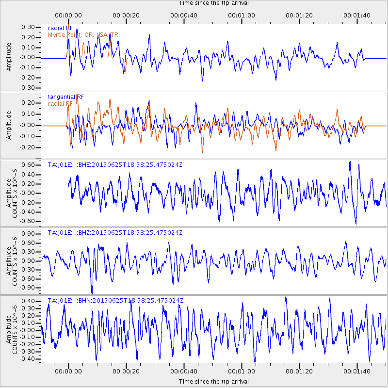
J01E Myrtle Point, OR, USA - Earthquake Result Viewer
*The percent match for this event was below the threshold and hence no stack was calculated.
| Earthquake location: |
South Of Kermadec Islands |
| Earthquake latitude/longitude: |
-32.0/-178.2 |
| Earthquake time(UTC): |
2015/06/25 (176) 18:45:58 GMT |
| Earthquake Depth: |
10 km |
| Earthquake Magnitude: |
5.8 MB |
| Earthquake Catalog/Contributor: |
NEIC PDE/NEIC ALERT |
|
| Network: |
TA USArray Transportable Network (new EarthScope stations) |
| Station: |
J01E Myrtle Point, OR, USA |
| Lat/Lon: |
43.16 N/123.93 W |
| Elevation: |
128 m |
|
| Distance: |
89.8 deg |
| Az: |
36.436 deg |
| Baz: |
223.576 deg |
| Ray Param: |
$rayparam |
*The percent match for this event was below the threshold and hence was not used in the summary stack. |
|
| Radial Match: |
58.682465 % |
| Radial Bump: |
400 |
| Transverse Match: |
51.2865 % |
| Transverse Bump: |
400 |
| SOD ConfigId: |
7422571 |
| Insert Time: |
2019-04-19 11:55:10.501 +0000 |
| GWidth: |
2.5 |
| Max Bumps: |
400 |
| Tol: |
0.001 |
|
Signal To Noise
| Channel | StoN | STA | LTA |
| TA:J01E: :BHZ:20150625T18:58:25.475024Z | 1.5140353 | 2.5216792E-7 | 1.6655353E-7 |
| TA:J01E: :BHN:20150625T18:58:25.475024Z | 0.70710903 | 1.2810197E-7 | 1.8116297E-7 |
| TA:J01E: :BHE:20150625T18:58:25.475024Z | 0.7739666 | 1.467569E-7 | 1.8961657E-7 |
| Arrivals |
| Ps | |
| PpPs | |
| PsPs/PpSs | |


