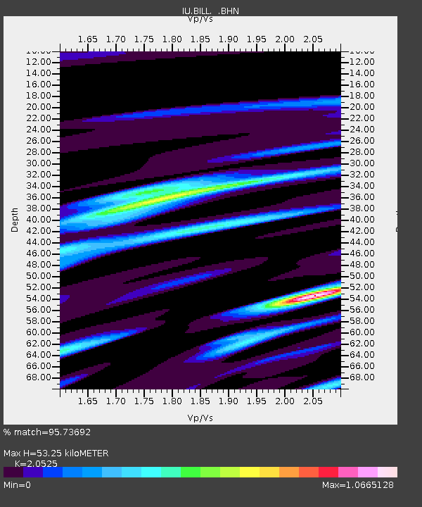
BILL Bilibino, Russia - Earthquake Result Viewer

Earthquake location: Southern Sumatra, Indonesia
Earthquake latitude/longitude: -0.5/99.3
Earthquake time(UTC): 1998/04/01 (091) 17:56:23 GMT
Earthquake Depth: 56 km
Earthquake Magnitude: 6.2 MB, 6.9 MS, 7.0 UNKNOWN, 6.6 ME
Earthquake Catalog/Contributor: WHDF/NEIC
Network: IU Global Seismograph Network (GSN - IRIS/USGS)
Station: BILL Bilibino, Russia
Lat/Lon: 68.07 N/166.45 E
Elevation: 299 m
Distance: 82.1 deg
Az: 20.465 deg
Baz: 248.517 deg
Ray Param: 0.04699748
Estimated Moho Depth: 53.25 km
Estimated Crust Vp/Vs: 2.05
Assumed Crust Vp: 6.577 km/s
Estimated Crust Vs: 3.204 km/s
Estimated Crust Poisson's Ratio: 0.34
Radial Match: 95.73692 %
Radial Bump: 400
Transverse Match: 87.17158 %
Transverse Bump: 400
SOD ConfigId: 4480
Insert Time: 2010-03-03 15:14:38.483 +0000
GWidth: 2.5
Max Bumps: 400
Tol: 0.001

Signal To Noise

ChannelStoNSTALTA
IU:BILL: :BHN:19980401T18:08:06.880994Z30.7826653.1234827E-61.01468885E-7
IU:BILL: :BHE:19980401T18:08:06.880994Z8.9420378.8968835E-79.9495054E-8
IU:BILL: :BHZ:19980401T18:08:06.880994Z12.52232551.1462358E-69.153538E-8
Arrivals
Ps8.7 SECOND
PpPs24 SECOND
PsPs/PpSs33 SECOND