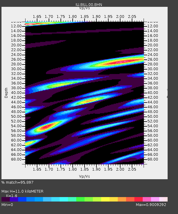
BILL Bilibino, Russia - Earthquake Result Viewer

Earthquake location: New Britain Region, P.N.G.
Earthquake latitude/longitude: -6.6/152.2
Earthquake time(UTC): 2005/12/11 (345) 14:20:43 GMT
Earthquake Depth: 10 km
Earthquake Magnitude: 6.2 MB, 6.2 MS, 6.6 MW, 6.5 MW
Earthquake Catalog/Contributor: WHDF/NEIC
Network: IU Global Seismograph Network (GSN - IRIS/USGS)
Station: BILL Bilibino, Russia
Lat/Lon: 68.07 N/166.45 E
Elevation: 299 m
Distance: 75.1 deg
Az: 5.494 deg
Baz: 194.664 deg
Ray Param: 0.05186738
Estimated Moho Depth: 11.0 km
Estimated Crust Vp/Vs: 1.60
Assumed Crust Vp: 6.577 km/s
Estimated Crust Vs: 4.11 km/s
Estimated Crust Poisson's Ratio: 0.18
Radial Match: 95.897 %
Radial Bump: 344
Transverse Match: 81.88036 %
Transverse Bump: 400
SOD ConfigId: 2422
Insert Time: 2010-03-03 15:15:02.634 +0000
GWidth: 2.5
Max Bumps: 400
Tol: 0.001

Signal To Noise

ChannelStoNSTALTA
IU:BILL:00:BHN:20051211T14:31:54.748008Z13.14954951.6213572E-61.2330135E-7
IU:BILL:00:BHE:20051211T14:31:54.748008Z3.17036633.3842417E-71.06746086E-7
IU:BILL:00:BHZ:20051211T14:31:54.748008Z38.375723.0995373E-68.076818E-8
Arrivals
Ps1.0 SECOND
PpPs4.2 SECOND
PsPs/PpSs5.2 SECOND