You are here: Home > Network List > IU - Global Seismograph Network (GSN - IRIS/USGS) Stations List
> Station SLBS Sierra la Laguna Baja California Sur, Mexico > Earthquake Result Viewer
SLBS Sierra la Laguna Baja California Sur, Mexico - Earthquake Result Viewer

| Earthquake location: |
South Of Kermadec Islands |
| Earthquake latitude/longitude: |
-32.2/-178.0 |
| Earthquake time(UTC): |
2015/06/25 (176) 19:14:05 GMT |
| Earthquake Depth: |
10 km |
| Earthquake Magnitude: |
4.9 mb, 4.9 mb, 5.2 MS |
| Earthquake Catalog/Contributor: |
ISC/ISC |
|
| Network: |
IU Global Seismograph Network (GSN - IRIS/USGS) |
| Station: |
SLBS Sierra la Laguna Baja California Sur, Mexico |
| Lat/Lon: |
23.69 N/109.94 W |
| Elevation: |
825 m |
|
| Distance: |
85.5 deg |
| Az: |
58.522 deg |
| Baz: |
232.037 deg |
| Ray Param: |
0.04472487 |
| Estimated Moho Depth: |
61.75 km |
| Estimated Crust Vp/Vs: |
2.10 |
| Assumed Crust Vp: |
6.183 km/s |
| Estimated Crust Vs: |
2.948 km/s |
| Estimated Crust Poisson's Ratio: |
0.35 |
|
| Radial Match: |
92.973434 % |
| Radial Bump: |
400 |
| Transverse Match: |
52.03635 % |
| Transverse Bump: |
400 |
| SOD ConfigId: |
7422571 |
| Insert Time: |
2019-04-19 11:58:32.101 +0000 |
| GWidth: |
2.5 |
| Max Bumps: |
400 |
| Tol: |
0.001 |
|
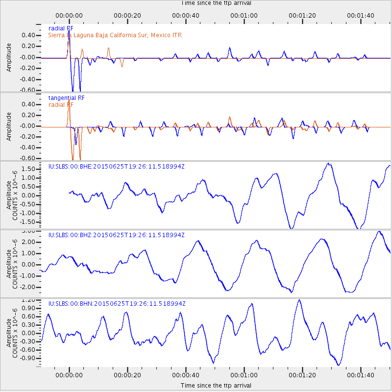
Signal To Noise
| Channel | StoN | STA | LTA |
| IU:SLBS:00:BHZ:20150625T19:26:11.518994Z | 1.6519313 | 5.643408E-7 | 3.4162485E-7 |
| IU:SLBS:00:BHN:20150625T19:26:11.518994Z | 0.35753727 | 1.0007519E-7 | 2.7990143E-7 |
| IU:SLBS:00:BHE:20150625T19:26:11.518994Z | 1.7455298 | 5.604769E-7 | 3.210927E-7 |
| Arrivals |
| Ps | 11 SECOND |
| PpPs | 30 SECOND |
| PsPs/PpSs | 42 SECOND |


