You are here: Home > Network List > US - United States National Seismic Network Stations List
> Station CBKS Cedar Bluff, Kansas, USA > Earthquake Result Viewer
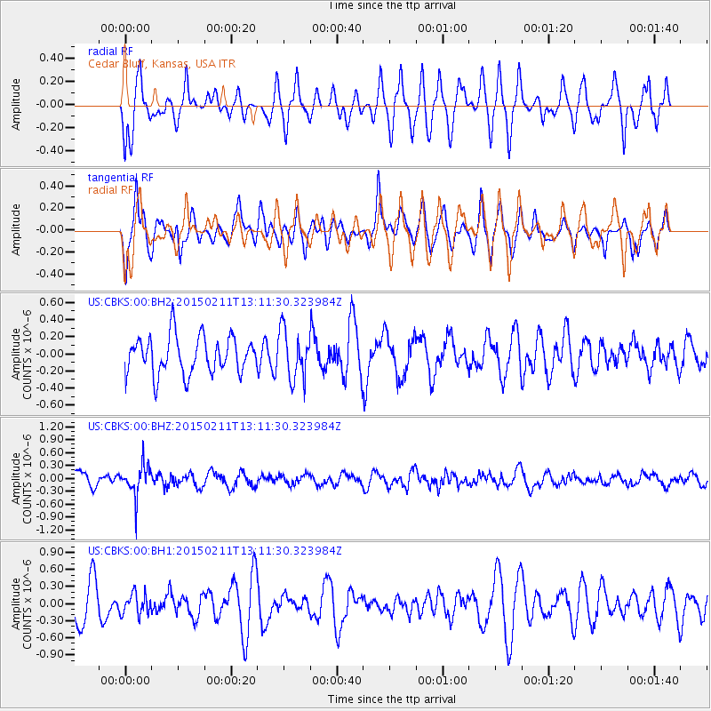
CBKS Cedar Bluff, Kansas, USA - Earthquake Result Viewer
*The percent match for this event was below the threshold and hence no stack was calculated.
| Earthquake location: |
Jujuy Province, Argentina |
| Earthquake latitude/longitude: |
-23.5/-66.7 |
| Earthquake time(UTC): |
2015/02/11 (042) 13:01:15 GMT |
| Earthquake Depth: |
201 km |
| Earthquake Magnitude: |
5.5 MWW |
| Earthquake Catalog/Contributor: |
NEIC PDE/NEIC COMCAT |
|
| Network: |
US United States National Seismic Network |
| Station: |
CBKS Cedar Bluff, Kansas, USA |
| Lat/Lon: |
38.81 N/99.74 W |
| Elevation: |
677 m |
|
| Distance: |
69.3 deg |
| Az: |
332.929 deg |
| Baz: |
147.682 deg |
| Ray Param: |
$rayparam |
*The percent match for this event was below the threshold and hence was not used in the summary stack. |
|
| Radial Match: |
56.048325 % |
| Radial Bump: |
400 |
| Transverse Match: |
51.733555 % |
| Transverse Bump: |
400 |
| SOD ConfigId: |
872571 |
| Insert Time: |
2015-02-25 13:14:16.268 +0000 |
| GWidth: |
2.5 |
| Max Bumps: |
400 |
| Tol: |
0.001 |
|
Signal To Noise
| Channel | StoN | STA | LTA |
| US:CBKS:00:BHZ:20150211T13:11:30.323984Z | 1.9831153 | 3.6351068E-7 | 1.8330284E-7 |
| US:CBKS:00:BH1:20150211T13:11:30.323984Z | 0.460909 | 1.8332614E-7 | 3.9774906E-7 |
| US:CBKS:00:BH2:20150211T13:11:30.323984Z | 1.3140548 | 2.8651326E-7 | 2.1803753E-7 |
| Arrivals |
| Ps | |
| PpPs | |
| PsPs/PpSs | |


