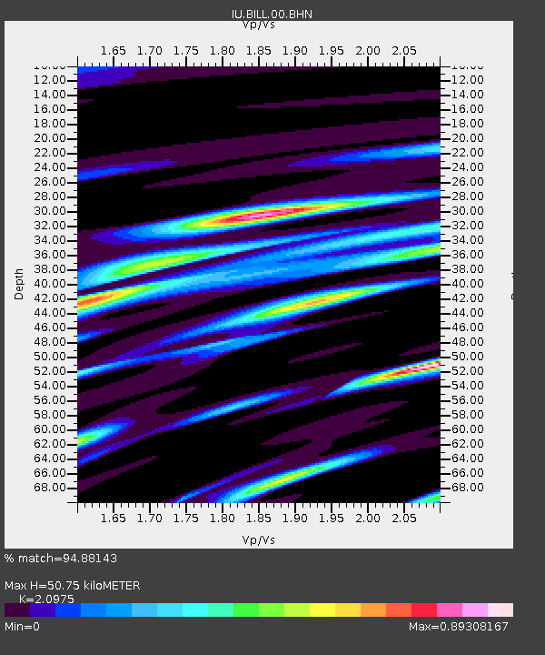
BILL Bilibino, Russia - Earthquake Result Viewer
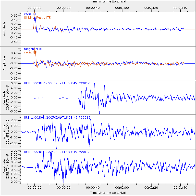
Earthquake location: Bonin Islands, Japan Region
Earthquake latitude/longitude: 26.1/144.0
Earthquake time(UTC): 2005/02/09 (040) 18:46:09 GMT
Earthquake Depth: 24 km
Earthquake Magnitude: 6.2 MB, 6.3 MS, 6.3 MW, 6.3 MW
Earthquake Catalog/Contributor: WHDF/NEIC
Network: IU Global Seismograph Network (GSN - IRIS/USGS)
Station: BILL Bilibino, Russia
Lat/Lon: 68.07 N/166.45 E
Elevation: 299 m
Distance: 44.1 deg
Az: 11.891 deg
Baz: 209.55 deg
Ray Param: 0.07205965
Estimated Moho Depth: 50.75 km
Estimated Crust Vp/Vs: 2.10
Assumed Crust Vp: 6.577 km/s
Estimated Crust Vs: 3.136 km/s
Estimated Crust Poisson's Ratio: 0.35
Radial Match: 94.88143 %
Radial Bump: 388
Transverse Match: 79.10527 %
Transverse Bump: 400
SOD ConfigId: 5233
Insert Time: 2010-03-03 15:15:11.215 +0000
GWidth: 2.5
Max Bumps: 400
Tol: 0.001

Signal To Noise

ChannelStoNSTALTA
IU:BILL:00:BHN:20050209T18:53:45.79901Z4.5981227.11971E-71.5483951E-7
IU:BILL:00:BHE:20050209T18:53:45.79901Z2.40013935.9542697E-72.4808017E-7
IU:BILL:00:BHZ:20050209T18:53:45.79901Z33.080132.0880977E-66.312241E-8
Arrivals
Ps9.0 SECOND
PpPs23 SECOND
PsPs/PpSs32 SECOND