You are here: Home > Network List > CI - Caltech Regional Seismic Network Stations List
> Station DAN Danby, California, USA > Earthquake Result Viewer
DAN Danby, California, USA - Earthquake Result Viewer
| Earthquake location: |
South Of Kermadec Islands |
| Earthquake latitude/longitude: |
-32.2/-178.0 |
| Earthquake time(UTC): |
2015/06/25 (176) 19:18:05 GMT |
| Earthquake Depth: |
10 km |
| Earthquake Magnitude: |
4.8 mb, 4.7 mb, 4.9 MS |
| Earthquake Catalog/Contributor: |
ISC/ISC |
|
| Network: |
CI Caltech Regional Seismic Network |
| Station: |
DAN Danby, California, USA |
| Lat/Lon: |
34.64 N/115.38 W |
| Elevation: |
398 m |
|
| Distance: |
88.8 deg |
| Az: |
47.08 deg |
| Baz: |
228.816 deg |
| Ray Param: |
0.042318694 |
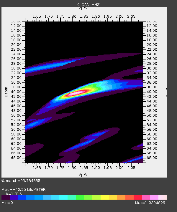
| Estimated Moho Depth: |
40.25 km |
| Estimated Crust Vp/Vs: |
1.82 |
| Assumed Crust Vp: |
6.276 km/s |
| Estimated Crust Vs: |
3.458 km/s |
| Estimated Crust Poisson's Ratio: |
0.28 |
|
| Radial Match: |
93.754585 % |
| Radial Bump: |
400 |
| Transverse Match: |
77.51539 % |
| Transverse Bump: |
400 |
| SOD ConfigId: |
7422571 |
| Insert Time: |
2019-04-19 12:02:05.489 +0000 |
| GWidth: |
2.5 |
| Max Bumps: |
400 |
| Tol: |
0.001 |
|
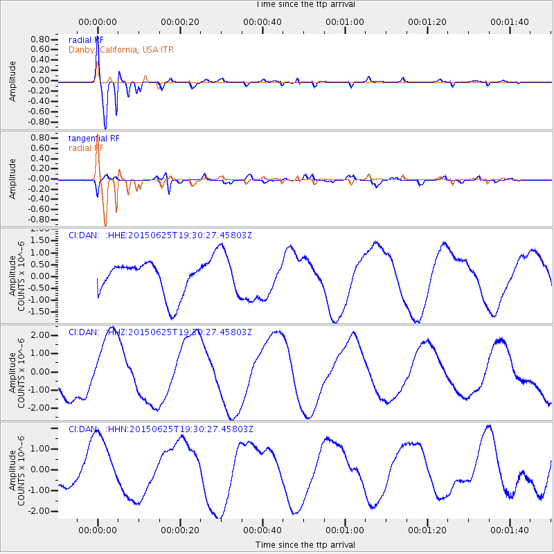
Signal To Noise
| Channel | StoN | STA | LTA |
| CI:DAN: :HHZ:20150625T19:30:27.45803Z | 1.8062677 | 1.957423E-6 | 1.0836837E-6 |
| CI:DAN: :HHN:20150625T19:30:27.45803Z | 1.9984765 | 1.4572448E-6 | 7.291778E-7 |
| CI:DAN: :HHE:20150625T19:30:27.45803Z | 1.4381461 | 9.938886E-7 | 6.910902E-7 |
| Arrivals |
| Ps | 5.3 SECOND |
| PpPs | 18 SECOND |
| PsPs/PpSs | 23 SECOND |


