You are here: Home > Network List > UW - Pacific Northwest Regional Seismic Network Stations List
> Station GNW Green Mountain (BB) > Earthquake Result Viewer
GNW Green Mountain (BB) - Earthquake Result Viewer
| Earthquake location: |
South Of Kermadec Islands |
| Earthquake latitude/longitude: |
-32.2/-178.0 |
| Earthquake time(UTC): |
2015/06/25 (176) 19:18:05 GMT |
| Earthquake Depth: |
10 km |
| Earthquake Magnitude: |
4.8 mb, 4.7 mb, 4.9 MS |
| Earthquake Catalog/Contributor: |
ISC/ISC |
|
| Network: |
UW Pacific Northwest Regional Seismic Network |
| Station: |
GNW Green Mountain (BB) |
| Lat/Lon: |
47.56 N/122.83 W |
| Elevation: |
160 m |
|
| Distance: |
93.6 deg |
| Az: |
33.849 deg |
| Baz: |
224.184 deg |
| Ray Param: |
0.04122766 |
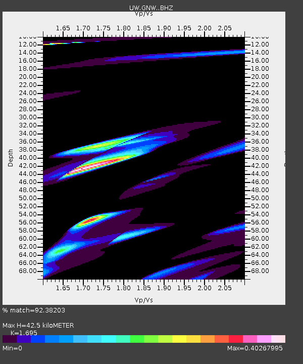
| Estimated Moho Depth: |
42.5 km |
| Estimated Crust Vp/Vs: |
1.70 |
| Assumed Crust Vp: |
6.566 km/s |
| Estimated Crust Vs: |
3.874 km/s |
| Estimated Crust Poisson's Ratio: |
0.23 |
|
| Radial Match: |
92.38203 % |
| Radial Bump: |
400 |
| Transverse Match: |
79.16206 % |
| Transverse Bump: |
400 |
| SOD ConfigId: |
7422571 |
| Insert Time: |
2019-04-19 12:05:07.274 +0000 |
| GWidth: |
2.5 |
| Max Bumps: |
400 |
| Tol: |
0.001 |
|

Signal To Noise
| Channel | StoN | STA | LTA |
| UW:GNW: :BHZ:20150625T19:30:49.695029Z | 1.8188244 | 9.0955393E-7 | 5.0007793E-7 |
| UW:GNW: :BHN:20150625T19:30:49.695029Z | 1.0865228 | 5.015493E-7 | 4.616096E-7 |
| UW:GNW: :BHE:20150625T19:30:49.695029Z | 0.42753685 | 1.8048479E-7 | 4.2215024E-7 |
| Arrivals |
| Ps | 4.6 SECOND |
| PpPs | 17 SECOND |
| PsPs/PpSs | 22 SECOND |


