You are here: Home > Network List > TA - USArray Transportable Network (new EarthScope stations) Stations List
> Station J04D Umpqua National Forest, Toketee, OR, USA > Earthquake Result Viewer
J04D Umpqua National Forest, Toketee, OR, USA - Earthquake Result Viewer
| Earthquake location: |
South Of Kermadec Islands |
| Earthquake latitude/longitude: |
-32.2/-178.0 |
| Earthquake time(UTC): |
2015/06/25 (176) 19:18:05 GMT |
| Earthquake Depth: |
10 km |
| Earthquake Magnitude: |
4.8 mb, 4.7 mb, 4.9 MS |
| Earthquake Catalog/Contributor: |
ISC/ISC |
|
| Network: |
TA USArray Transportable Network (new EarthScope stations) |
| Station: |
J04D Umpqua National Forest, Toketee, OR, USA |
| Lat/Lon: |
43.24 N/122.11 W |
| Elevation: |
1948 m |
|
| Distance: |
90.9 deg |
| Az: |
37.236 deg |
| Baz: |
224.561 deg |
| Ray Param: |
0.041642826 |
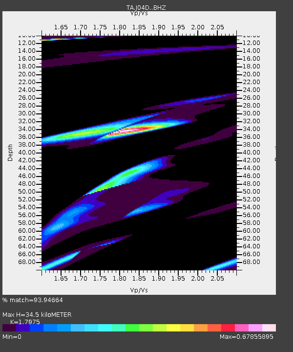
| Estimated Moho Depth: |
34.5 km |
| Estimated Crust Vp/Vs: |
1.80 |
| Assumed Crust Vp: |
6.522 km/s |
| Estimated Crust Vs: |
3.628 km/s |
| Estimated Crust Poisson's Ratio: |
0.28 |
|
| Radial Match: |
93.94664 % |
| Radial Bump: |
400 |
| Transverse Match: |
83.60955 % |
| Transverse Bump: |
400 |
| SOD ConfigId: |
7422571 |
| Insert Time: |
2019-04-19 12:05:12.773 +0000 |
| GWidth: |
2.5 |
| Max Bumps: |
400 |
| Tol: |
0.001 |
|
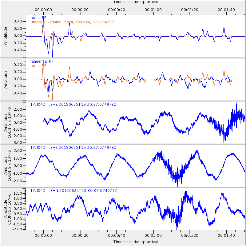
Signal To Noise
| Channel | StoN | STA | LTA |
| TA:J04D: :BHZ:20150625T19:30:37.074973Z | 1.7753031 | 1.3005055E-6 | 7.32554E-7 |
| TA:J04D: :BHN:20150625T19:30:37.074973Z | 0.92903477 | 3.7093233E-7 | 3.9926636E-7 |
| TA:J04D: :BHE:20150625T19:30:37.074973Z | 0.69011056 | 6.0390937E-7 | 8.7509073E-7 |
| Arrivals |
| Ps | 4.3 SECOND |
| PpPs | 14 SECOND |
| PsPs/PpSs | 19 SECOND |


