You are here: Home > Network List > ZE15 - Southern Alaska Lithosphere and Mantle Observation Network Stations List
> Station MPEN Moose Pens 2, Alaska > Earthquake Result Viewer
MPEN Moose Pens 2, Alaska - Earthquake Result Viewer
| Earthquake location: |
South Of Kermadec Islands |
| Earthquake latitude/longitude: |
-32.2/-178.0 |
| Earthquake time(UTC): |
2015/06/25 (176) 19:18:05 GMT |
| Earthquake Depth: |
10 km |
| Earthquake Magnitude: |
4.8 mb, 4.7 mb, 4.9 MS |
| Earthquake Catalog/Contributor: |
ISC/ISC |
|
| Network: |
ZE Southern Alaska Lithosphere and Mantle Observation Network |
| Station: |
MPEN Moose Pens 2, Alaska |
| Lat/Lon: |
60.74 N/150.48 W |
| Elevation: |
124 m |
|
| Distance: |
95.3 deg |
| Az: |
13.178 deg |
| Baz: |
203.152 deg |
| Ray Param: |
0.040807087 |
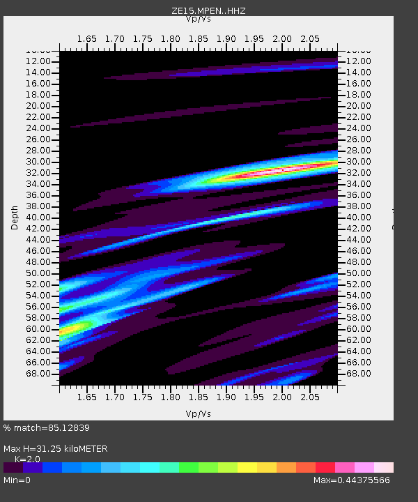
| Estimated Moho Depth: |
31.25 km |
| Estimated Crust Vp/Vs: |
2.00 |
| Assumed Crust Vp: |
6.302 km/s |
| Estimated Crust Vs: |
3.151 km/s |
| Estimated Crust Poisson's Ratio: |
0.33 |
|
| Radial Match: |
85.12839 % |
| Radial Bump: |
237 |
| Transverse Match: |
55.091965 % |
| Transverse Bump: |
400 |
| SOD ConfigId: |
7422571 |
| Insert Time: |
2019-04-19 12:05:55.684 +0000 |
| GWidth: |
2.5 |
| Max Bumps: |
400 |
| Tol: |
0.001 |
|

Signal To Noise
| Channel | StoN | STA | LTA |
| ZE:MPEN: :HHZ:20150625T19:30:57.599021Z | 1.7592988 | 9.125755E-7 | 5.1871547E-7 |
| ZE:MPEN: :HHN:20150625T19:30:57.599021Z | 1.2761679 | 9.095549E-7 | 7.1272353E-7 |
| ZE:MPEN: :HHE:20150625T19:30:57.599021Z | 0.64629996 | 5.966324E-7 | 9.2315094E-7 |
| Arrivals |
| Ps | 5.0 SECOND |
| PpPs | 15 SECOND |
| PsPs/PpSs | 20 SECOND |


