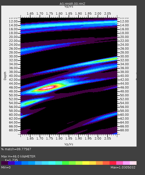
HHAR Hobbs,AR - Earthquake Result Viewer

Earthquake location: Jujuy Province, Argentina
Earthquake latitude/longitude: -23.1/-66.7
Earthquake time(UTC): 2015/02/11 (042) 18:57:22 GMT
Earthquake Depth: 223 km
Earthquake Magnitude: 6.7 MWW, 6.7 MWC, 6.7 MWB, 6.9 MI
Earthquake Catalog/Contributor: NEIC PDE/NEIC COMCAT
Network: AG Arkansas Seismic Network
Station: HHAR Hobbs,AR
Lat/Lon: 36.28 N/93.94 W
Elevation: 421 m
Distance: 64.4 deg
Az: 335.789 deg
Baz: 152.141 deg
Ray Param: 0.058244716
Estimated Moho Depth: 46.0 km
Estimated Crust Vp/Vs: 1.74
Assumed Crust Vp: 6.53 km/s
Estimated Crust Vs: 3.764 km/s
Estimated Crust Poisson's Ratio: 0.25
Radial Match: 89.77567 %
Radial Bump: 365
Transverse Match: 55.83809 %
Transverse Bump: 400
SOD ConfigId: 872571
Insert Time: 2015-02-25 18:59:23.456 +0000
GWidth: 2.5
Max Bumps: 400
Tol: 0.001

Signal To Noise

ChannelStoNSTALTA
AG:HHAR:00:HHZ:20150211T19:07:04.009978Z16.0696494.7422163E-62.9510392E-7
AG:HHAR:00:HHN:20150211T19:07:04.009978Z4.68901351.525629E-63.253625E-7
AG:HHAR:00:HHE:20150211T19:07:04.009978Z6.02578931.2285728E-62.038858E-7
Arrivals
Ps5.4 SECOND
PpPs18 SECOND
PsPs/PpSs24 SECOND