You are here: Home > Network List > CI - Caltech Regional Seismic Network Stations List
> Station SBC Santa Barbara, Santa Barbara, CA, USA > Earthquake Result Viewer
SBC Santa Barbara, Santa Barbara, CA, USA - Earthquake Result Viewer

| Earthquake location: |
Fiji Islands Region |
| Earthquake latitude/longitude: |
-22.0/-179.5 |
| Earthquake time(UTC): |
2008/01/15 (015) 17:52:15 GMT |
| Earthquake Depth: |
598 km |
| Earthquake Magnitude: |
5.8 MB, 6.5 MW, 6.5 MW |
| Earthquake Catalog/Contributor: |
WHDF/NEIC |
|
| Network: |
CI Caltech Regional Seismic Network |
| Station: |
SBC Santa Barbara, Santa Barbara, CA, USA |
| Lat/Lon: |
34.44 N/119.71 W |
| Elevation: |
94 m |
|
| Distance: |
79.9 deg |
| Az: |
46.535 deg |
| Baz: |
234.596 deg |
| Ray Param: |
0.046823755 |
| Estimated Moho Depth: |
10.0 km |
| Estimated Crust Vp/Vs: |
1.60 |
| Assumed Crust Vp: |
6.1 km/s |
| Estimated Crust Vs: |
3.812 km/s |
| Estimated Crust Poisson's Ratio: |
0.18 |
|
| Radial Match: |
99.55067 % |
| Radial Bump: |
36 |
| Transverse Match: |
94.75702 % |
| Transverse Bump: |
99 |
| SOD ConfigId: |
2564 |
| Insert Time: |
2010-02-25 21:35:20.143 +0000 |
| GWidth: |
2.5 |
| Max Bumps: |
400 |
| Tol: |
0.001 |
|
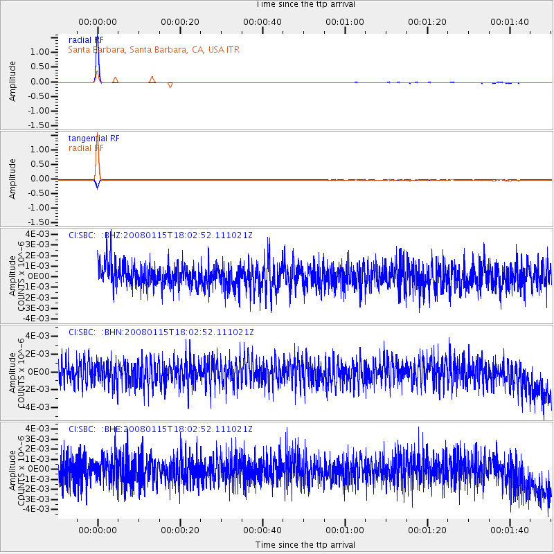
Signal To Noise
| Channel | StoN | STA | LTA |
| CI:SBC: :BHN:20080115T18:02:52.111021Z | 0.99707186 | 1.2012307E-9 | 1.2047583E-9 |
| CI:SBC: :BHE:20080115T18:02:52.111021Z | 0.9805258 | 1.2120714E-9 | 1.2361444E-9 |
| CI:SBC: :BHZ:20080115T18:02:52.111021Z | 1.0928242 | 1.1211001E-9 | 1.0258742E-9 |
| Arrivals |
| Ps | 1.0 SECOND |
| PpPs | 4.2 SECOND |
| PsPs/PpSs | 5.2 SECOND |


