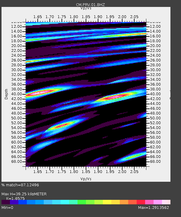
PRV Islas San Andres y Providencia, Colombia - Earthquake Result Viewer

Earthquake location: Jujuy Province, Argentina
Earthquake latitude/longitude: -23.1/-66.7
Earthquake time(UTC): 2015/02/11 (042) 18:57:22 GMT
Earthquake Depth: 223 km
Earthquake Magnitude: 6.7 MWW, 6.7 MWC, 6.7 MWB, 6.9 MI
Earthquake Catalog/Contributor: NEIC PDE/NEIC COMCAT
Network: CM Red Sismologica Nacional de Columbia
Station: PRV Islas San Andres y Providencia, Colombia
Lat/Lon: 13.38 N/81.36 W
Elevation: 205 m
Distance: 39.0 deg
Az: 336.939 deg
Baz: 158.249 deg
Ray Param: 0.074381776
Estimated Moho Depth: 39.25 km
Estimated Crust Vp/Vs: 1.66
Assumed Crust Vp: 6.048 km/s
Estimated Crust Vs: 3.649 km/s
Estimated Crust Poisson's Ratio: 0.21
Radial Match: 87.12496 %
Radial Bump: 400
Transverse Match: 79.19855 %
Transverse Bump: 400
SOD ConfigId: 872571
Insert Time: 2015-02-25 19:00:02.654 +0000
GWidth: 2.5
Max Bumps: 400
Tol: 0.001

Signal To Noise

ChannelStoNSTALTA
CM:PRV:01:BHZ:20150211T19:03:56.683013Z26.4468941.0507009E-63.9728704E-8
CM:PRV:01:BHN:20150211T19:03:56.683013Z10.1336934.026242E-73.973124E-8
CM:PRV:01:BHE:20150211T19:03:56.683013Z7.0194363.01619E-74.296912E-8
Arrivals
Ps4.6 SECOND
PpPs16 SECOND
PsPs/PpSs21 SECOND