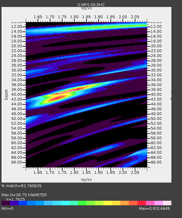
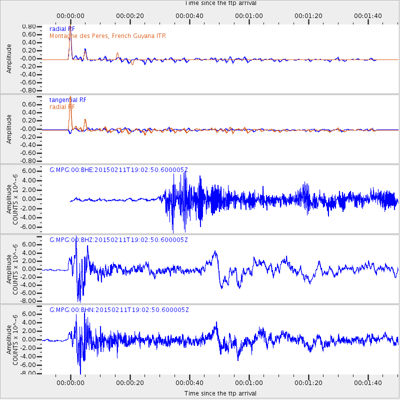
MPG Montagne des Peres, French Guyana - Earthquake Result Viewer

Earthquake location: Jujuy Province, Argentina
Earthquake latitude/longitude: -23.1/-66.7
Earthquake time(UTC): 2015/02/11 (042) 18:57:22 GMT
Earthquake Depth: 223 km
Earthquake Magnitude: 6.7 MWW, 6.7 MWC, 6.7 MWB, 6.9 MI
Earthquake Catalog/Contributor: NEIC PDE/NEIC COMCAT
Network: G GEOSCOPE
Station: MPG Montagne des Peres, French Guyana
Lat/Lon: 5.11 N/52.64 W
Elevation: 147 m
Distance: 31.2 deg
Az: 27.801 deg
Baz: 205.539 deg
Ray Param: 0.078484446
Estimated Moho Depth: 38.75 km
Estimated Crust Vp/Vs: 1.76
Assumed Crust Vp: 6.472 km/s
Estimated Crust Vs: 3.672 km/s
Estimated Crust Poisson's Ratio: 0.26
Radial Match: 93.760635 %
Radial Bump: 310
Transverse Match: 75.21608 %
Transverse Bump: 400
SOD ConfigId: 872571
Insert Time: 2015-02-25 19:01:03.189 +0000
GWidth: 2.5
Max Bumps: 400
Tol: 0.001

Signal To Noise

ChannelStoNSTALTA
G:MPG:00:BHZ:20150211T19:02:50.600005Z19.252173.8303024E-61.9895434E-7
G:MPG:00:BHN:20150211T19:02:50.600005Z19.5472162.848888E-61.4574393E-7
G:MPG:00:BHE:20150211T19:02:50.600005Z11.468411.8857663E-61.6443137E-7
Arrivals
Ps4.9 SECOND
PpPs15 SECOND
PsPs/PpSs20 SECOND