You are here: Home > Network List > US - United States National Seismic Network Stations List
> Station MNTX Cornudas Mountains, Texas, USA > Earthquake Result Viewer
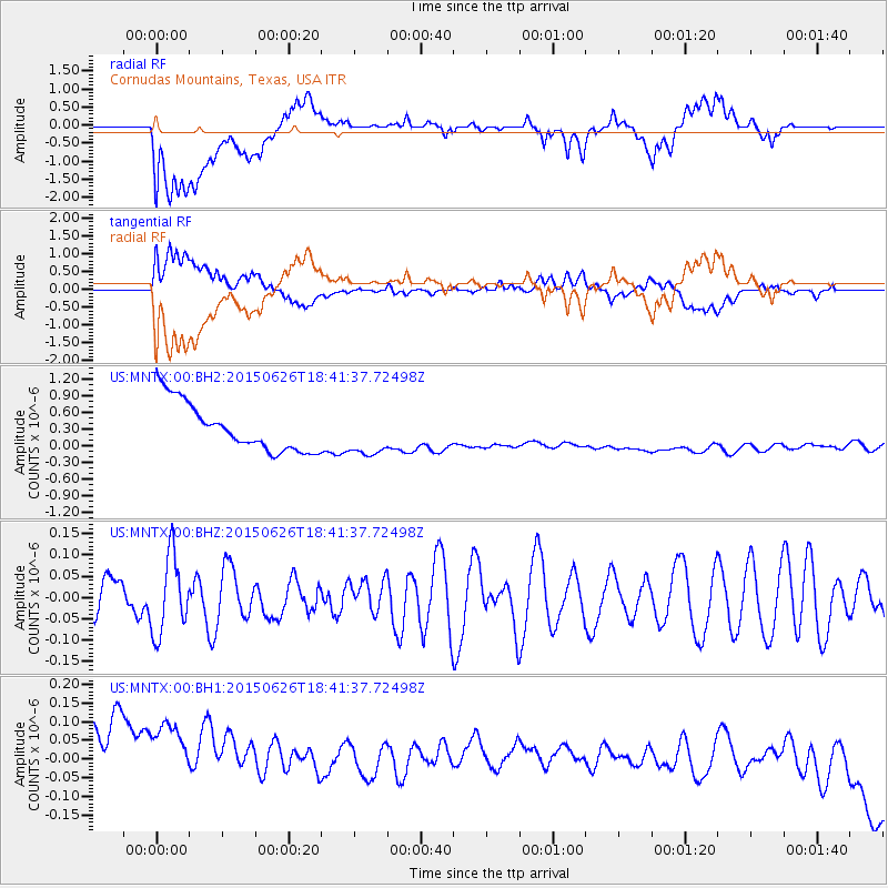
MNTX Cornudas Mountains, Texas, USA - Earthquake Result Viewer
*The percent match for this event was below the threshold and hence no stack was calculated.
| Earthquake location: |
Kuril Islands |
| Earthquake latitude/longitude: |
44.0/146.9 |
| Earthquake time(UTC): |
2015/06/26 (177) 18:30:08 GMT |
| Earthquake Depth: |
82 km |
| Earthquake Magnitude: |
4.8 MW, 4.8 mb |
| Earthquake Catalog/Contributor: |
ISC/ISC |
|
| Network: |
US United States National Seismic Network |
| Station: |
MNTX Cornudas Mountains, Texas, USA |
| Lat/Lon: |
31.70 N/105.38 W |
| Elevation: |
404 m |
|
| Distance: |
79.9 deg |
| Az: |
55.582 deg |
| Baz: |
315.712 deg |
| Ray Param: |
$rayparam |
*The percent match for this event was below the threshold and hence was not used in the summary stack. |
|
| Radial Match: |
23.150597 % |
| Radial Bump: |
400 |
| Transverse Match: |
27.983006 % |
| Transverse Bump: |
400 |
| SOD ConfigId: |
7422571 |
| Insert Time: |
2019-04-19 12:26:06.061 +0000 |
| GWidth: |
2.5 |
| Max Bumps: |
400 |
| Tol: |
0.001 |
|
Signal To Noise
| Channel | StoN | STA | LTA |
| US:MNTX:00:BHZ:20150626T18:41:37.72498Z | 1.7999858 | 9.159053E-8 | 5.088403E-8 |
| US:MNTX:00:BH1:20150626T18:41:37.72498Z | 0.9234889 | 3.2892015E-7 | 3.5617117E-7 |
| US:MNTX:00:BH2:20150626T18:41:37.72498Z | 0.9391782 | 4.077557E-7 | 4.3416222E-7 |
| Arrivals |
| Ps | |
| PpPs | |
| PsPs/PpSs | |


