You are here: Home > Network List > IU - Global Seismograph Network (GSN - IRIS/USGS) Stations List
> Station BILL Bilibino, Russia > Earthquake Result Viewer
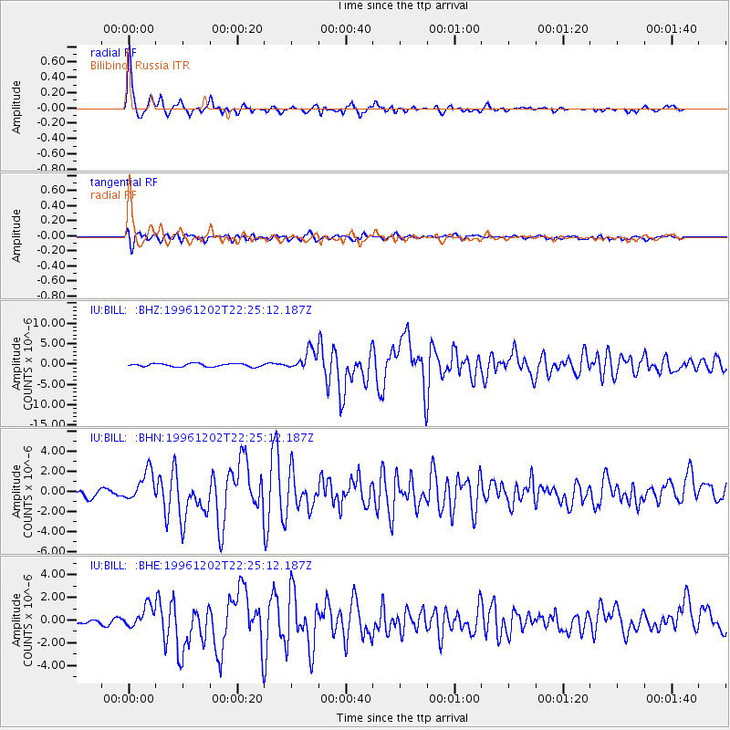
BILL Bilibino, Russia - Earthquake Result Viewer

| Earthquake location: |
Kyushu, Japan |
| Earthquake latitude/longitude: |
31.8/131.3 |
| Earthquake time(UTC): |
1996/12/02 (337) 22:17:59 GMT |
| Earthquake Depth: |
49 km |
| Earthquake Magnitude: |
6.0 MB, 6.6 MS, 6.8 UNKNOWN, 6.3 ME |
| Earthquake Catalog/Contributor: |
WHDF/NEIC |
|
| Network: |
IU Global Seismograph Network (GSN - IRIS/USGS) |
| Station: |
BILL Bilibino, Russia |
| Lat/Lon: |
68.07 N/166.45 E |
| Elevation: |
299 m |
|
| Distance: |
41.6 deg |
| Az: |
18.997 deg |
| Baz: |
227.546 deg |
| Ray Param: |
0.07353771 |
| Estimated Moho Depth: |
41.0 km |
| Estimated Crust Vp/Vs: |
1.60 |
| Assumed Crust Vp: |
6.577 km/s |
| Estimated Crust Vs: |
4.11 km/s |
| Estimated Crust Poisson's Ratio: |
0.18 |
|
| Radial Match: |
95.197044 % |
| Radial Bump: |
317 |
| Transverse Match: |
76.69431 % |
| Transverse Bump: |
400 |
| SOD ConfigId: |
6273 |
| Insert Time: |
2010-03-03 15:18:06.039 +0000 |
| GWidth: |
2.5 |
| Max Bumps: |
400 |
| Tol: |
0.001 |
|
Signal To Noise
| Channel | StoN | STA | LTA |
| IU:BILL: :BHN:19961202T22:25:12.187Z | 3.7703853 | 1.5395831E-6 | 4.0833575E-7 |
| IU:BILL: :BHE:19961202T22:25:12.187Z | 5.4195876 | 9.806175E-7 | 1.8093951E-7 |
| IU:BILL: :BHZ:19961202T22:25:12.187Z | 6.66407 | 2.4635647E-6 | 3.696787E-7 |
| Arrivals |
| Ps | 4.1 SECOND |
| PpPs | 15 SECOND |
| PsPs/PpSs | 19 SECOND |


